Holcomb geodata
Holcomb (Missouri) is a populated place; located in United States in America/Chicago (GMT-5) time zone. With population of 607 people, there are 19621 cities with bigger population in this country. Compared to other cities in United States, 68.5% of cities are located further ↑North; 59.1% of cities are located further →East and 73% of cities have higher elevation than Holcomb. Note1


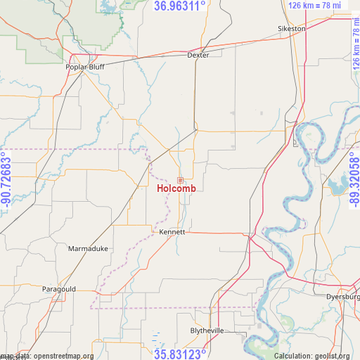
Holcomb GPS coordinates[2]
36° 23' 57.228" North, 90° 1' 25.32" West
| Map corner | latitude | longitude |
|---|---|---|
| Upper-left | 36.96311°, | -90.72683° |
| Center: | 36.39923°, | -90.0237° |
| Lower-right: | 35.83123°, | -89.32058° |
| Map W x H: | 125.9×125.9 km | = 78.2×78.2mi |
| max Lat: | 71.29058° ⇑68.5% North |
| Holcomb: | 36.39923° |
| min Lat: | ⇓31.5% South 19.06759° |
| min Long | Holcomb | max Long |
| -171.73463° | -90.0237° | -66.98998° |
| W 40.9%⇐ | ⇒59.1% E |
Elevation
Elevation of Holcomb is 83 m = 272 ft, and this is 211.8 m = 695 ft below average elevation for this country.
| Max E: |
3189 m = 10463 ft | 73% |
| Avg. | 294.8 m = 967 ft | |
| Holcomb | 83 m = 272 ft | |
Min E: |
-60 m = -197 ft | 27% |
See also: United States elevation on elevation.city.
Geographical zone
Holcomb is located in North temperate zone (between Tropic of Cancer and the Arctic Circle). Distance of this Northern Tropic circle is 1441.3 km =895.6 mi to South.| Distance of | km | miles | from Holcomb |
|---|---|---|---|
| North Pole | 5959.8 | 3703.2 | to North |
| Arctic Circle | 3354 | 2084.1 | to North |
| Tropic Cancer | 1441.3 | 895.6 | to South |
| Equator | 4047.2 | 2514.8 | to South |


Nearby cities:
15 places around Holcomb: (largest is in red/bold)
• Bernie
30.4 km =18.9 mi,  9°
9°
• Campbell
11.4 km =7.1 mi,  336°
336°
• Clarkton
7.7 km =4.8 mi,  40°
40°
• Gideon
11 km =6.8 mi,  57°
57°
• Hayti
30.7 km =19.1 mi,  126°
126°
• Hayti Heights
29.3 km =18.2 mi, 128°
• Kennett
18.4 km =11.4 mi,  188°
188°
• Malden
18.3 km =11.4 mi,  16°
16°
• Marmaduke
39.9 km =24.8 mi,  233°
233°
• Parma
30.2 km =18.8 mi, 37°
• Piggott
15.1 km =9.4 mi,  263°
263°
• Portageville
29.2 km =18.1 mi,  84°
84°
• Rector
28.4 km =17.6 mi,  237°
237°
• Senath
31.9 km =19.8 mi,  202°
202°
• Steele
39.2 km =24.4 mi,  153°
153°
Sources, notices
• [Note1] Compared only with cities in United States existing in our database
• [Src1] Map data: © OpenStreetMap contributors (CC-BY-SA)
• [Src2] Other city data from geonames.org with taken over terms of usage.
• [Src3] Geographical zone / Annual Mean Temperature by Robert A. Rohde @ Wikipedia
