Rector geodata
Rector (Arkansas) is a populated place; located in United States in America/Chicago (GMT-5) time zone. With population of 1,840 people, there are 12408 cities with bigger population in this country. Compared to other cities in United States, 69.1% of cities are located further ↑North; 59.9% of cities are located further →East and 72% of cities have higher elevation than Rector. Note1
Administrative division(s):
- Level 1: Arkansas
- Level 2: Clay County
- Level 3: Township of East Oak Bluff-Blue Cane


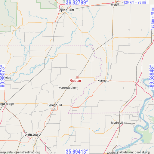
Rector GPS coordinates[2]
36° 15' 47.232" North, 90° 17' 33.36" West
| Map corner | latitude | longitude |
|---|---|---|
| Upper-left | 36.82799°, | -90.99573° |
| Center: | 36.26312°, | -90.2926° |
| Lower-right: | 35.69413°, | -89.58948° |
| Map W x H: | 126.1×126.1 km | = 78.4×78.4mi |
| max Lat: | 71.29058° ⇑69.1% North |
| Rector: | 36.26312° |
| min Lat: | ⇓30.9% South 19.06759° |
| min Long | Rector | max Long |
| -171.73463° | -90.2926° | -66.98998° |
| W 40.1%⇐ | ⇒59.9% E |
Elevation
Elevation of Rector is 89 m = 292 ft, and this is 205.8 m = 675 ft below average elevation for this country.
| Max E: |
3189 m = 10463 ft | 72% |
| Avg. | 294.8 m = 967 ft | |
| Rector | 89 m = 292 ft | |
Min E: |
-60 m = -197 ft | 28% |
See also: United States elevation on elevation.city.
Geographical zone
Rector is located in North temperate zone (between Tropic of Cancer and the Arctic Circle). Distance of this Northern Tropic circle is 1426.2 km =886.2 mi to South.| Distance of | km | miles | from Rector |
|---|---|---|---|
| North Pole | 5975 | 3712.7 | to North |
| Arctic Circle | 3369.1 | 2093.5 | to North |
| Tropic Cancer | 1426.2 | 886.2 | to South |
| Equator | 4032.1 | 2505.4 | to South |


Nearby cities:
15 places around Rector: (largest is in red/bold)
• Campbell
32.2 km =20 mi,  37°
37°
• Cardwell
24 km =14.9 mi,  180°
180°
• Clarkton
35.9 km =22.3 mi,  54°
54°
• Corning
30.3 km =18.8 mi,  302°
302°
• Gideon
39.5 km =24.5 mi,  57°
57°
• Holcomb
28.4 km =17.6 mi, 57°
• Hornersville
29.4 km =18.3 mi,  146°
146°
• Kennett
21.5 km =13.4 mi,  98°
98°
• Leachville
36.5 km =22.7 mi, 175°
• Marmaduke
11.7 km =7.3 mi,  223°
223°
• Monette
41.7 km =25.9 mi,  186°
186°
• Oak Grove Heights
25.2 km =15.7 mi,  231°
231°
• Paragould
29.3 km =18.2 mi, 218°
• Piggott
16.1 km =10 mi,  34°
34°
• Senath
18.6 km =11.6 mi,  140°
140°
Sources, notices
• [Note1] Compared only with cities in United States existing in our database
• [Src1] Map data: © OpenStreetMap contributors (CC-BY-SA)
• [Src2] Other city data from geonames.org with taken over terms of usage.
• [Src3] Geographical zone / Annual Mean Temperature by Robert A. Rohde @ Wikipedia
