Kennett geodata
Kennett (Missouri) is a seat of a second-order administrative division; located in United States in America/Chicago (GMT-5) time zone. With population of 10,662 people, there are 4282 cities with bigger population in this country. Compared to other cities in United States, 69.2% of cities are located further ↑North; 59.2% of cities are located further →East and 73.2% of cities have higher elevation than Kennett. Note1
Administrative division(s):
- Level 1: Missouri
- Level 2: Dunklin County
- Level 3: Township of Independence


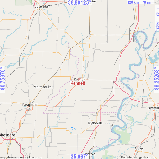
Kennett GPS coordinates[2]
36° 14' 10.248" North, 90° 3' 20.34" West
| Map corner | latitude | longitude |
|---|---|---|
| Upper-left | 36.80125°, | -90.75878° |
| Center: | 36.23618°, | -90.05565° |
| Lower-right: | 35.667°, | -89.35253° |
| Map W x H: | 126.1×126.1 km | = 78.4×78.4mi |
| max Lat: | 71.29058° ⇑69.2% North |
| Kennett: | 36.23618° |
| min Lat: | ⇓30.8% South 19.06759° |
| min Long | Kennett | max Long |
| -171.73463° | -90.05565° | -66.98998° |
| W 40.8%⇐ | ⇒59.2% E |
Elevation
Elevation of Kennett is 82 m = 269 ft, and this is 212.8 m = 698 ft below average elevation for this country.
| Max E: |
3189 m = 10463 ft | 73.2% |
| Avg. | 294.8 m = 967 ft | |
| Kennett | 82 m = 269 ft | |
Min E: |
-60 m = -197 ft | 26.8% |
See also: United States elevation on elevation.city.
Geographical zone
Kennett is located in North temperate zone (between Tropic of Cancer and the Arctic Circle). Distance of this Northern Tropic circle is 1423.2 km =884.3 mi to South.| Distance of | km | miles | from Kennett |
|---|---|---|---|
| North Pole | 5978 | 3714.6 | to North |
| Arctic Circle | 3372.1 | 2095.3 | to North |
| Tropic Cancer | 1423.2 | 884.3 | to South |
| Equator | 4029.1 | 2503.6 | to South |


Nearby cities:
15 places around Kennett: (largest is in red/bold)
• Campbell
28.7 km =17.8 mi,  356°
356°
• Cardwell
29.9 km =18.6 mi,  225°
225°
• Caruthersville
36.2 km =22.5 mi,  97°
97°
• Clarkton
25.2 km =15.7 mi,  18°
18°
• Gideon
26.9 km =16.7 mi,  26°
26°
• Gosnell
31.6 km =19.6 mi,  166°
166°
• Hayti
27.5 km =17.1 mi,  90°
90°
• Hayti Heights
25.7 km =16 mi, 90°
• Holcomb
18.4 km =11.4 mi,  8°
8°
• Hornersville
22.2 km =13.8 mi,  193°
193°
• Marmaduke
29.9 km =18.6 mi,  259°
259°
• Piggott
20.3 km =12.6 mi,  323°
323°
• Rector
21.5 km =13.4 mi,  278°
278°
• Senath
14.7 km =9.1 mi,  219°
219°
• Steele
26.4 km =16.4 mi,  129°
129°
Sources, notices
• [Note1] Compared only with cities in United States existing in our database
• [Src1] Map data: © OpenStreetMap contributors (CC-BY-SA)
• [Src2] Other city data from geonames.org with taken over terms of usage.
• [Src3] Geographical zone / Annual Mean Temperature by Robert A. Rohde @ Wikipedia
