Iberia geodata
Iberia (Missouri) is a populated place; located in United States in America/Chicago (GMT-5) time zone. With population of 743 people, there are 18279 cities with bigger population in this country. Compared to other cities in United States, 61.1% of cities are located further ↑North; 64.8% of cities are located further →East and 67.4% of cities have lower elevation than Iberia. Note1


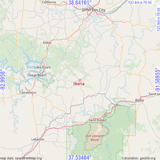
Iberia GPS coordinates[2]
38° 5' 25.152" North, 92° 17' 33.612" West
| Map corner | latitude | longitude |
|---|---|---|
| Upper-left | 38.64161°, | -92.9958° |
| Center: | 38.09032°, | -92.29267° |
| Lower-right: | 37.53484°, | -91.58955° |
| Map W x H: | 123.1×123.1 km | = 76.5×76.5mi |
| max Lat: | 71.29058° ⇑61.1% North |
| Iberia: | 38.09032° |
| min Lat: | ⇓38.9% South 19.06759° |
| min Long | Iberia | max Long |
| -171.73463° | -92.29267° | -66.98998° |
| W 35.2%⇐ | ⇒64.8% E |
Elevation
Elevation of Iberia is 273 m = 896 ft, and this is 21.8 m = 72 ft below average elevation for this country.
| Max E: |
3189 m = 10463 ft | 32.6% |
| Avg. | 294.8 m = 967 ft | |
| Iberia | 273 m = 896 ft | |
Min E: |
-60 m = -197 ft | 67.4% |
See also: United States elevation on elevation.city.
Geographical zone
Iberia is located in North temperate zone (between Tropic of Cancer and the Arctic Circle). Distance of this Northern Tropic circle is 1629.3 km =1012.4 mi to South.| Distance of | km | miles | from Iberia |
|---|---|---|---|
| North Pole | 5771.8 | 3586.4 | to North |
| Arctic Circle | 3165.9 | 1967.2 | to North |
| Tropic Cancer | 1629.3 | 1012.4 | to South |
| Equator | 4235.2 | 2631.6 | to South |


Nearby cities:
15 places around Iberia: (largest is in red/bold)
• Camdenton
40.6 km =25.2 mi,  256°
256°
• Crocker
15.9 km =9.9 mi,  170°
170°
• Dixon
20.6 km =12.8 mi,  122°
122°
• Doolittle
39.7 km =24.7 mi,  114°
114°
• Eldon
38.2 km =23.7 mi,  318°
318°
• Fort Leonard Wood
44.4 km =27.6 mi,  164°
164°
• Four Seasons
38.5 km =23.9 mi,  288°
288°
• Lake Ozark
32.6 km =20.3 mi, 291°
• Osage Beach
31.8 km =19.8 mi,  277°
277°
• Richland
27.7 km =17.2 mi,  200°
200°
• Saint Robert
30.8 km =19.1 mi, 160°
• Tuscumbia
21.5 km =13.4 mi, 317°
• Vienna
32.1 km =19.9 mi,  70°
70°
• Wardsville
45.5 km =28.3 mi,  13°
13°
• Waynesville
30.2 km =18.8 mi, 164°
Sources, notices
• [Note1] Compared only with cities in United States existing in our database
• [Src1] Map data: © OpenStreetMap contributors (CC-BY-SA)
• [Src2] Other city data from geonames.org with taken over terms of usage.
• [Src3] Geographical zone / Annual Mean Temperature by Robert A. Rohde @ Wikipedia
