Lathrop geodata
Lathrop (Missouri) is a populated place; located in United States in America/Chicago (GMT-5) time zone. With population of 2,049 people, there are 11796 cities with bigger population in this country. Compared to other cities in United States, 50.5% of cities are located further ↑North; 69.4% of cities are located further →East and 76.9% of cities have lower elevation than Lathrop. Note1


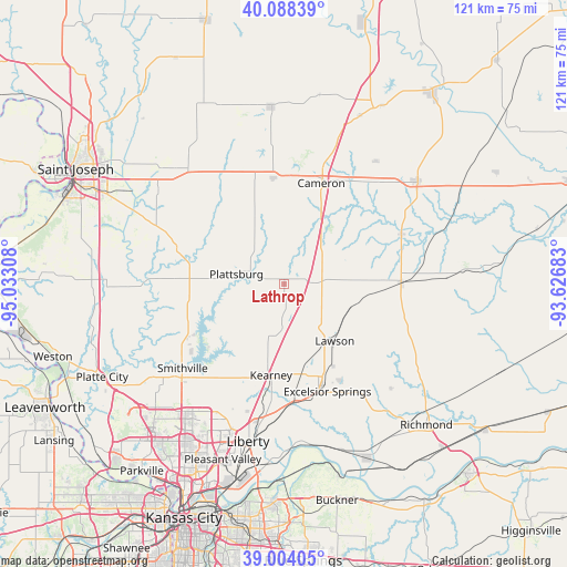
Lathrop GPS coordinates[2]
39° 32' 54.024" North, 94° 19' 47.82" West
| Map corner | latitude | longitude |
|---|---|---|
| Upper-left | 40.08839°, | -95.03308° |
| Center: | 39.54834°, | -94.32995° |
| Lower-right: | 39.00405°, | -93.62683° |
| Map W x H: | 120.6×120.6 km | = 74.9×74.9mi |
| max Lat: | 71.29058° ⇑50.5% North |
| Lathrop: | 39.54834° |
| min Lat: | ⇓49.5% South 19.06759° |
| min Long | Lathrop | max Long |
| -171.73463° | -94.32995° | -66.98998° |
| W 30.6%⇐ | ⇒69.4% E |
Elevation
Elevation of Lathrop is 327 m = 1073 ft, and this is 32.2 m = 106 ft above average elevation for this country.
| Max E: |
3189 m = 10463 ft | 23.1% |
| Lathrop | 327 m 1073 ft | |
| Avg. | 294.8 m = 967 ft | |
Min E: |
-60 m = -197 ft | 76.9% |
See also: United States elevation on elevation.city.
Geographical zone
Lathrop is located in North temperate zone (between Tropic of Cancer and the Arctic Circle). Distance of this Northern Tropic circle is 1791.4 km =1113.1 mi to South.| Distance of | km | miles | from Lathrop |
|---|---|---|---|
| North Pole | 5609.7 | 3485.7 | to North |
| Arctic Circle | 3003.8 | 1866.5 | to North |
| Tropic Cancer | 1791.4 | 1113.1 | to South |
| Equator | 4397.4 | 2732.4 | to South |


Nearby cities:
15 places around Lathrop: (largest is in red/bold)
• Cameron
22.7 km =14.1 mi,  19°
19°
• Edgerton
26.5 km =16.5 mi,  259°
259°
• Excelsior Springs
24.9 km =15.5 mi,  159°
159°
• Gower
24.1 km =15 mi,  286°
286°
• Hamilton
35.7 km =22.2 mi,  52°
52°
• Kearney
20.3 km =12.6 mi,  187°
187°
• Kingston
27.1 km =16.8 mi,  66°
66°
• Lawson
16.3 km =10.1 mi,  138°
138°
• Liberty
34.5 km =21.4 mi, 192°
• Plattsburg
10.3 km =6.4 mi,  280°
280°
• Polo
24.8 km =15.4 mi,  89°
89°
• Smithville
28 km =17.4 mi,  230°
230°
• Stewartsville
26.7 km =16.6 mi,  327°
327°
• Trimble
21.9 km =13.6 mi,  246°
246°
• Wood Heights
27.3 km =17 mi,  148°
148°
Sources, notices
• [Note1] Compared only with cities in United States existing in our database
• [Src1] Map data: © OpenStreetMap contributors (CC-BY-SA)
• [Src2] Other city data from geonames.org with taken over terms of usage.
• [Src3] Geographical zone / Annual Mean Temperature by Robert A. Rohde @ Wikipedia
