Oregon geodata
Oregon (Missouri) is a seat of a second-order administrative division; located in United States in America/Chicago (GMT-5) time zone. With population of 776 people, there are 18014 cities with bigger population in this country. Compared to other cities in United States, 53.4% of cities are located further ↓South; 71.5% of cities are located further →East and 78.2% of cities have lower elevation than Oregon. Note1


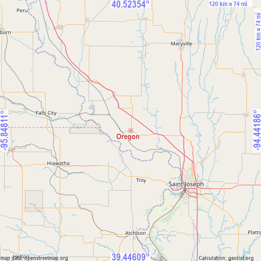
Oregon GPS coordinates[2]
39° 59' 12.984" North, 95° 8' 41.928" West
| Map corner | latitude | longitude |
|---|---|---|
| Upper-left | 40.52354°, | -95.84811° |
| Center: | 39.98694°, | -95.14498° |
| Lower-right: | 39.44609°, | -94.44186° |
| Map W x H: | 119.8×119.8 km | = 74.4×74.4mi |
| max Lat: | 71.29058° ⇑46.6% North |
| Oregon: | 39.98694° |
| min Lat: | ⇓53.4% South 19.06759° |
| min Long | Oregon | max Long |
| -171.73463° | -95.14498° | -66.98998° |
| W 28.5%⇐ | ⇒71.5% E |
Elevation
Elevation of Oregon is 337 m = 1106 ft, and this is 42.2 m = 138 ft above average elevation for this country.
| Max E: |
3189 m = 10463 ft | 21.8% |
| Oregon | 337 m 1106 ft | |
| Avg. | 294.8 m = 967 ft | |
Min E: |
-60 m = -197 ft | 78.2% |
See also: United States elevation on elevation.city.
Geographical zone
Oregon is located in North temperate zone (between Tropic of Cancer and the Arctic Circle). Distance of this Northern Tropic circle is 1840.2 km =1143.4 mi to South.| Distance of | km | miles | from Oregon |
|---|---|---|---|
| North Pole | 5560.9 | 3455.4 | to North |
| Arctic Circle | 2955 | 1836.2 | to North |
| Tropic Cancer | 1840.2 | 1143.4 | to South |
| Equator | 4446.1 | 2762.7 | to South |


Nearby cities:
15 places around Oregon: (largest is in red/bold)
• Atchison
47.2 km =29.3 mi,  177°
177°
• Burlington Junction
51.4 km =31.9 mi,  7°
7°
• Country Club Village
32.5 km =20.2 mi,  121°
121°
• Elwood
34.7 km =21.6 mi,  137°
137°
• Fairfax
44.4 km =27.6 mi,  331°
331°
• Falls City
39.8 km =24.7 mi,  281°
281°
• Hiawatha
36.5 km =22.7 mi,  245°
245°
• Highland
17.7 km =11 mi,  216°
216°
• Horton
48.8 km =30.3 mi, 221°
• Maryville
46.2 km =28.7 mi,  30°
30°
• Mound City
17.6 km =10.9 mi,  335°
335°
• Saint Joseph
35.2 km =21.9 mi,  133°
133°
• Savannah
27.3 km =17 mi,  100°
100°
• Troy
23.2 km =14.4 mi,  168°
168°
• Wathena
30.3 km =18.8 mi,  146°
146°
Sources, notices
• [Note1] Compared only with cities in United States existing in our database
• [Src1] Map data: © OpenStreetMap contributors (CC-BY-SA)
• [Src2] Other city data from geonames.org with taken over terms of usage.
• [Src3] Geographical zone / Annual Mean Temperature by Robert A. Rohde @ Wikipedia
