Highland geodata
Highland (Kansas) is a populated place; located in United States in America/Chicago (GMT-5) time zone. With population of 1,010 people, there are 16223 cities with bigger population in this country. Compared to other cities in United States, 52.1% of cities are located further ↓South; 71.8% of cities are located further →East and 76.8% of cities have lower elevation than Highland. Note1


Highland GPS coordinates[2]
39° 51' 34.992" North, 95° 16' 10.92" West
| Map corner | latitude | longitude |
|---|---|---|
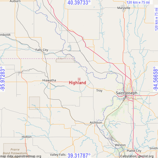
| Upper-left | 40.39733°, | -95.97283° |
| Center: | 39.85972°, | -95.2697° |
| Lower-right: | 39.31787°, | -94.56658° |
| Map W x H: | 120×120 km | = 74.6×74.6mi |
| max Lat: | 71.29058° ⇑47.9% North |
| Highland: | 39.85972° |
| min Lat: | ⇓52.1% South 19.06759° |
| min Long | Highland | max Long |
| -171.73463° | -95.2697° | -66.98998° |
| W 28.2%⇐ | ⇒71.8% E |
Elevation
Elevation of Highland is 326 m = 1070 ft, and this is 31.2 m = 102 ft above average elevation for this country.
| Max E: |
3189 m = 10463 ft | 23.2% |
| Highland | 326 m 1070 ft | |
| Avg. | 294.8 m = 967 ft | |
Min E: |
-60 m = -197 ft | 76.8% |
See also: United States elevation on elevation.city.
Geographical zone
Highland is located in North temperate zone (between Tropic of Cancer and the Arctic Circle). Distance of this Northern Tropic circle is 1826.1 km =1134.7 mi to South.| Distance of | km | miles | from Highland |
|---|---|---|---|
| North Pole | 5575.1 | 3464.2 | to North |
| Arctic Circle | 2969.2 | 1845 | to North |
| Tropic Cancer | 1826.1 | 1134.7 | to South |
| Equator | 4432 | 2753.9 | to South |


Nearby cities:
15 places around Highland: (largest is in red/bold)
• Atchison
35.3 km =21.9 mi,  158°
158°
• Country Club Village
38.4 km =23.9 mi,  94°
94°
• Effingham
39.2 km =24.4 mi,  196°
196°
• Elwood
35.9 km =22.3 mi,  108°
108°
• Falls City
36.1 km =22.4 mi,  308°
308°
• Hiawatha
22.7 km =14.1 mi,  267°
267°
• Horton
31.2 km =19.4 mi,  224°
224°
• Mound City
30.3 km =18.8 mi,  6°
6°
• Nortonville
49.6 km =30.8 mi,  186°
186°
• Oregon
17.7 km =11 mi,  36°
36°
• Sabetha
45.6 km =28.3 mi,  275°
275°
• Saint Joseph
37.5 km =23.3 mi, 105°
• Savannah
38.6 km =24 mi,  76°
76°
• Troy
17.6 km =10.9 mi,  119°
119°
• Wathena
29.5 km =18.3 mi, 112°
Sources, notices
• [Note1] Compared only with cities in United States existing in our database
• [Src1] Map data: © OpenStreetMap contributors (CC-BY-SA)
• [Src2] Other city data from geonames.org with taken over terms of usage.
• [Src3] Geographical zone / Annual Mean Temperature by Robert A. Rohde @ Wikipedia
