Owensville geodata
Owensville (Missouri) is a populated place; located in United States in America/Chicago (GMT-5) time zone. With population of 2,627 people, there are 10335 cities with bigger population in this country. Compared to other cities in United States, 59.7% of cities are located further ↑North; 63.1% of cities are located further →East and 71.3% of cities have lower elevation than Owensville. Note1


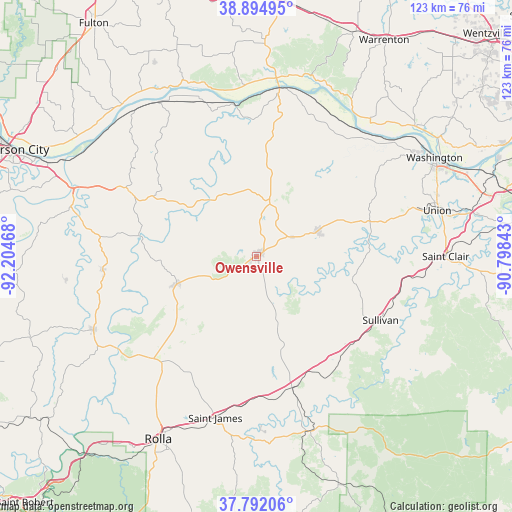
Owensville GPS coordinates[2]
38° 20' 44.16" North, 91° 30' 5.58" West
| Map corner | latitude | longitude |
|---|---|---|
| Upper-left | 38.89495°, | -92.20468° |
| Center: | 38.3456°, | -91.50155° |
| Lower-right: | 37.79206°, | -90.79843° |
| Map W x H: | 122.6×122.6 km | = 76.2×76.2mi |
| max Lat: | 71.29058° ⇑59.7% North |
| Owensville: | 38.3456° |
| min Lat: | ⇓40.3% South 19.06759° |
| min Long | Owensville | max Long |
| -171.73463° | -91.50155° | -66.98998° |
| W 36.9%⇐ | ⇒63.1% E |
Elevation
Elevation of Owensville is 292 m = 958 ft, and this is 2.8 m = 9 ft below average elevation for this country.
| Max E: |
3189 m = 10463 ft | 28.7% |
| Avg. | 294.8 m = 967 ft | |
| Owensville | 292 m = 958 ft | |
Min E: |
-60 m = -197 ft | 71.3% |
See also: United States elevation on elevation.city.
Geographical zone
Owensville is located in North temperate zone (between Tropic of Cancer and the Arctic Circle). Distance of this Northern Tropic circle is 1657.7 km =1030 mi to South.| Distance of | km | miles | from Owensville |
|---|---|---|---|
| North Pole | 5743.4 | 3568.8 | to North |
| Arctic Circle | 3137.5 | 1949.6 | to North |
| Tropic Cancer | 1657.7 | 1030 | to South |
| Equator | 4263.6 | 2649.3 | to South |


Nearby cities:
15 places around Owensville: (largest is in red/bold)
• Belle
20.2 km =12.6 mi,  250°
250°
• Bland
12.5 km =7.8 mi, 246°
• Bourbon
30.9 km =19.2 mi,  133°
133°
• Cuba
32.6 km =20.3 mi,  164°
164°
• Gerald
16.1 km =10 mi,  67°
67°
• Hermann
40.3 km =25 mi,  7°
7°
• Linn
34.2 km =21.3 mi,  297°
297°
• New Haven
38.2 km =23.7 mi,  40°
40°
• Saint Clair
45.4 km =28.2 mi,  90°
90°
• Saint James
40 km =24.9 mi,  194°
194°
• Steelville
43.9 km =27.3 mi, 163°
• Sullivan
33.5 km =20.8 mi,  117°
117°
• Union
44.5 km =27.7 mi, 74°
• Vienna
42.7 km =26.5 mi, 245°
• Washington
48.7 km =30.3 mi,  60°
60°
Sources, notices
• [Note1] Compared only with cities in United States existing in our database
• [Src1] Map data: © OpenStreetMap contributors (CC-BY-SA)
• [Src2] Other city data from geonames.org with taken over terms of usage.
• [Src3] Geographical zone / Annual Mean Temperature by Robert A. Rohde @ Wikipedia
