Washington geodata
Washington (Missouri) is a populated place; located in United States in America/Chicago (GMT-5) time zone. With population of 14,050 people, there are 3427 cities with bigger population in this country. Compared to other cities in United States, 58.4% of cities are located further ↑North; 62.1% of cities are located further →East and 56.9% of cities have higher elevation than Washington. Note1
Administrative division(s):
- Level 1: Missouri
- Level 2: Franklin County
- Level 3: Township of Washington


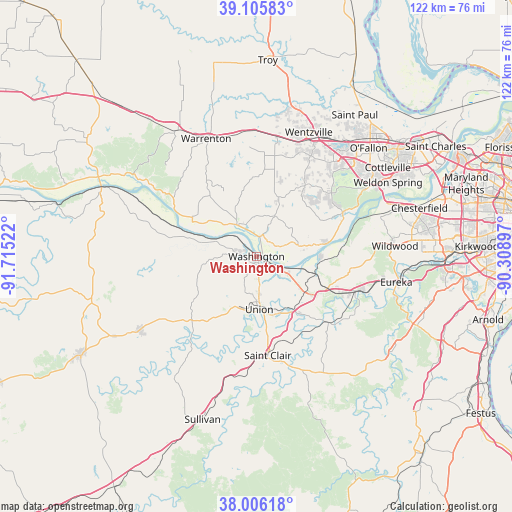
Washington GPS coordinates[2]
38° 33' 29.196" North, 91° 0' 43.524" West
| Map corner | latitude | longitude |
|---|---|---|
| Upper-left | 39.10583°, | -91.71522° |
| Center: | 38.55811°, | -91.01209° |
| Lower-right: | 38.00618°, | -90.30897° |
| Map W x H: | 122.3×122.3 km | = 76×76mi |
| max Lat: | 71.29058° ⇑58.4% North |
| Washington: | 38.55811° |
| min Lat: | ⇓41.6% South 19.06759° |
| min Long | Washington | max Long |
| -171.73463° | -91.01209° | -66.98998° |
| W 37.9%⇐ | ⇒62.1% E |
Elevation
Elevation of Washington is 171 m = 561 ft, and this is 123.8 m = 406 ft below average elevation for this country.
| Max E: |
3189 m = 10463 ft | 56.9% |
| Avg. | 294.8 m = 967 ft | |
| Washington | 171 m = 561 ft | |
Min E: |
-60 m = -197 ft | 43.1% |
See also: United States elevation on elevation.city.
Geographical zone
Washington is located in North temperate zone (between Tropic of Cancer and the Arctic Circle). Distance of this Northern Tropic circle is 1681.3 km =1044.7 mi to South.| Distance of | km | miles | from Washington |
|---|---|---|---|
| North Pole | 5719.8 | 3554.1 | to North |
| Arctic Circle | 3113.9 | 1934.9 | to North |
| Tropic Cancer | 1681.3 | 1044.7 | to South |
| Equator | 4287.3 | 2664 | to South |


Nearby cities:
15 places around Washington: (largest is in red/bold)
• Foristell
29 km =18 mi,  9°
9°
• Gerald
32.8 km =20.4 mi,  237°
237°
• Gray Summit
18.6 km =11.6 mi,  114°
114°
• Innsbrook
23.7 km =14.7 mi,  351°
351°
• Marthasville
8.8 km =5.5 mi,  333°
333°
• New Haven
18.8 km =11.7 mi,  287°
287°
• Pacific
25 km =15.5 mi, 109°
• Saint Clair
23.8 km =14.8 mi,  173°
173°
• Truesdale
30 km =18.6 mi,  339°
339°
• Union
12 km =7.5 mi,  178°
178°
• Villa Ridge
14.5 km =9 mi,  131°
131°
• Warrenton
30.3 km =18.8 mi, 338°
• Wentzville
31.4 km =19.5 mi,  26°
26°
• Wildwood
30.5 km =19 mi,  84°
84°
• Wright City
30 km =18.6 mi,  358°
358°
Sources, notices
• [Note1] Compared only with cities in United States existing in our database
• [Src1] Map data: © OpenStreetMap contributors (CC-BY-SA)
• [Src2] Other city data from geonames.org with taken over terms of usage.
• [Src3] Geographical zone / Annual Mean Temperature by Robert A. Rohde @ Wikipedia
