Steelville geodata
Steelville (Missouri) is a seat of a second-order administrative division; located in United States in America/Chicago (GMT-5) time zone. With population of 1,699 people, there are 12911 cities with bigger population in this country. Compared to other cities in United States, 61.8% of cities are located further ↑North; 62.8% of cities are located further →East and 58.2% of cities have lower elevation than Steelville. Note1


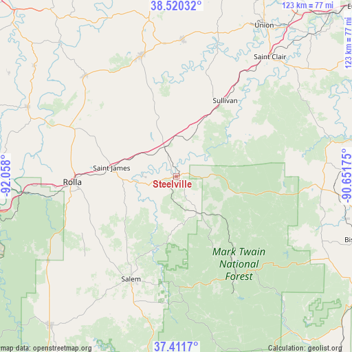
Steelville GPS coordinates[2]
37° 58' 5.16" North, 91° 21' 17.532" West
| Map corner | latitude | longitude |
|---|---|---|
| Upper-left | 38.52032°, | -92.058° |
| Center: | 37.9681°, | -91.35487° |
| Lower-right: | 37.4117°, | -90.65175° |
| Map W x H: | 123.3×123.3 km | = 76.6×76.6mi |
| max Lat: | 71.29058° ⇑61.8% North |
| Steelville: | 37.9681° |
| min Lat: | ⇓38.2% South 19.06759° |
| min Long | Steelville | max Long |
| -171.73463° | -91.35487° | -66.98998° |
| W 37.2%⇐ | ⇒62.8% E |
Elevation
Elevation of Steelville is 231 m = 758 ft, and this is 63.8 m = 209 ft below average elevation for this country.
| Max E: |
3189 m = 10463 ft | 41.8% |
| Avg. | 294.8 m = 967 ft | |
| Steelville | 231 m = 758 ft | |
Min E: |
-60 m = -197 ft | 58.2% |
See also: United States elevation on elevation.city.
Geographical zone
Steelville is located in North temperate zone (between Tropic of Cancer and the Arctic Circle). Distance of this Northern Tropic circle is 1615.7 km =1003.9 mi to South.| Distance of | km | miles | from Steelville |
|---|---|---|---|
| North Pole | 5785.4 | 3594.9 | to North |
| Arctic Circle | 3179.5 | 1975.6 | to North |
| Tropic Cancer | 1615.7 | 1003.9 | to South |
| Equator | 4221.7 | 2623.2 | to South |


Nearby cities:
15 places around Steelville: (largest is in red/bold)
• Belle
47.7 km =29.6 mi,  317°
317°
• Bland
44.4 km =27.6 mi,  326°
326°
• Bourbon
22.9 km =14.2 mi,  25°
25°
• Cuba
11.4 km =7.1 mi,  337°
337°
• Doolittle
46.2 km =28.7 mi,  266°
266°
• Gerald
48 km =29.8 mi,  2°
2°
• Owensville
43.9 km =27.3 mi, 343°
• Potosi
49.8 km =30.9 mi,  94°
94°
• Rolla
36.6 km =22.7 mi, 267°
• Saint Clair
53.2 km =33.1 mi,  37°
37°
• Saint James
23 km =14.3 mi,  278°
278°
• Salem
39.2 km =24.4 mi,  203°
203°
• Sullivan
31.6 km =19.6 mi, 32°
• Viburnum
34.1 km =21.2 mi,  145°
145°
• Vienna
57.3 km =35.6 mi,  295°
295°
Sources, notices
• [Note1] Compared only with cities in United States existing in our database
• [Src1] Map data: © OpenStreetMap contributors (CC-BY-SA)
• [Src2] Other city data from geonames.org with taken over terms of usage.
• [Src3] Geographical zone / Annual Mean Temperature by Robert A. Rohde @ Wikipedia
