Pacific geodata
Pacific (Missouri) is a populated place; located in United States in America/Chicago (GMT-5) time zone. With population of 7,161 people, there are 5723 cities with bigger population in this country. Compared to other cities in United States, 58.9% of cities are located further ↑North; 61.5% of cities are located further →East and 62.6% of cities have higher elevation than Pacific. Note1


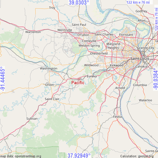
Pacific GPS coordinates[2]
38° 28' 55.2" North, 90° 44' 29.472" West
| Map corner | latitude | longitude |
|---|---|---|
| Upper-left | 39.0303°, | -91.44465° |
| Center: | 38.482°, | -90.74152° |
| Lower-right: | 37.92949°, | -90.0384° |
| Map W x H: | 122.4×122.4 km | = 76.1×76.1mi |
| max Lat: | 71.29058° ⇑58.9% North |
| Pacific: | 38.482° |
| min Lat: | ⇓41.1% South 19.06759° |
| min Long | Pacific | max Long |
| -171.73463° | -90.74152° | -66.98998° |
| W 38.5%⇐ | ⇒61.5% E |
Elevation
Elevation of Pacific is 141 m = 463 ft, and this is 153.8 m = 505 ft below average elevation for this country.
| Max E: |
3189 m = 10463 ft | 62.6% |
| Avg. | 294.8 m = 967 ft | |
| Pacific | 141 m = 463 ft | |
Min E: |
-60 m = -197 ft | 37.4% |
See also: United States elevation on elevation.city.
Geographical zone
Pacific is located in North temperate zone (between Tropic of Cancer and the Arctic Circle). Distance of this Northern Tropic circle is 1672.9 km =1039.5 mi to South.| Distance of | km | miles | from Pacific |
|---|---|---|---|
| North Pole | 5728.3 | 3559.4 | to North |
| Arctic Circle | 3122.4 | 1940.2 | to North |
| Tropic Cancer | 1672.9 | 1039.5 | to South |
| Equator | 4278.8 | 2658.7 | to South |


Nearby cities:
15 places around Pacific: (largest is in red/bold)
• Ballwin
21.1 km =13.1 mi,  53°
53°
• Byrnes Mill
14.7 km =9.1 mi,  109°
109°
• Cedar Hill
16.8 km =10.4 mi,  148°
148°
• Clarkson Valley
20.1 km =12.5 mi,  41°
41°
• Ellisville
18.2 km =11.3 mi, 47°
• Eureka
10.1 km =6.3 mi,  76°
76°
• Gray Summit
6.6 km =4.1 mi,  277°
277°
• High Ridge
18 km =11.2 mi,  98°
98°
• LaBarque Creek
9 km =5.6 mi,  143°
143°
• Murphy
22.2 km =13.8 mi,  87°
87°
• Union
23.5 km =14.6 mi,  261°
261°
• Valley Park
22.9 km =14.2 mi,  70°
70°
• Villa Ridge
12.7 km =7.9 mi,  265°
265°
• Wildwood
13.1 km =8.1 mi,  31°
31°
• Winchester
22.1 km =13.7 mi,  57°
57°
Sources, notices
• [Note1] Compared only with cities in United States existing in our database
• [Src1] Map data: © OpenStreetMap contributors (CC-BY-SA)
• [Src2] Other city data from geonames.org with taken over terms of usage.
• [Src3] Geographical zone / Annual Mean Temperature by Robert A. Rohde @ Wikipedia
