Wildwood geodata
Wildwood (Missouri) is a populated place; located in United States in America/Chicago (GMT-5) time zone. With population of 35,899 people, there are 1368 cities with bigger population in this country. Compared to other cities in United States, 58.2% of cities are located further ↑North; 61.4% of cities are located further →East and 59% of cities have lower elevation than Wildwood. Note1
Administrative division(s):
- Level 1: Missouri
- Level 2: Saint Louis County
- Level 3: Township of Chesterfield


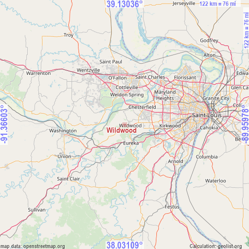
Wildwood GPS coordinates[2]
38° 34' 58.188" North, 90° 39' 46.44" West
| Map corner | latitude | longitude |
|---|---|---|
| Upper-left | 39.13036°, | -91.36603° |
| Center: | 38.58283°, | -90.6629° |
| Lower-right: | 38.03109°, | -89.95978° |
| Map W x H: | 122.2×122.2 km | = 75.9×75.9mi |
| max Lat: | 71.29058° ⇑58.2% North |
| Wildwood: | 38.58283° |
| min Lat: | ⇓41.8% South 19.06759° |
| min Long | Wildwood | max Long |
| -171.73463° | -90.6629° | -66.98998° |
| W 38.6%⇐ | ⇒61.4% E |
Elevation
Elevation of Wildwood is 235 m = 771 ft, and this is 59.8 m = 196 ft below average elevation for this country.
| Max E: |
3189 m = 10463 ft | 41% |
| Avg. | 294.8 m = 967 ft | |
| Wildwood | 235 m = 771 ft | |
Min E: |
-60 m = -197 ft | 59% |
See also: United States elevation on elevation.city.
Geographical zone
Wildwood is located in North temperate zone (between Tropic of Cancer and the Arctic Circle). Distance of this Northern Tropic circle is 1684.1 km =1046.5 mi to South.| Distance of | km | miles | from Wildwood |
|---|---|---|---|
| North Pole | 5717.1 | 3552.4 | to North |
| Arctic Circle | 3111.2 | 1933.2 | to North |
| Tropic Cancer | 1684.1 | 1046.5 | to South |
| Equator | 4290 | 2665.7 | to South |


Nearby cities:
15 places around Wildwood: (largest is in red/bold)
• Ballwin
10.2 km =6.3 mi,  82°
82°
• Byrnes Mill
17.6 km =10.9 mi,  156°
156°
• Chesterfield
11.6 km =7.2 mi,  39°
39°
• Clarkson Valley
7.5 km =4.7 mi,  58°
58°
• Cottleville
18.2 km =11.3 mi,  2°
2°
• Ellisville
6.7 km =4.2 mi, 80°
• Eureka
9.4 km =5.8 mi, 161°
• Gray Summit
16.9 km =10.5 mi,  232°
232°
• High Ridge
17.6 km =10.9 mi,  141°
141°
• Manchester
13.4 km =8.3 mi, 83°
• Pacific
13.1 km =8.1 mi,  211°
211°
• Town and Country
17.6 km =10.9 mi, 79°
• Valley Park
15.3 km =9.5 mi,  104°
104°
• Weldon Spring
14.7 km =9.1 mi,  351°
351°
• Winchester
11.8 km =7.3 mi,  85°
85°
Sources, notices
• [Note1] Compared only with cities in United States existing in our database
• [Src1] Map data: © OpenStreetMap contributors (CC-BY-SA)
• [Src2] Other city data from geonames.org with taken over terms of usage.
• [Src3] Geographical zone / Annual Mean Temperature by Robert A. Rohde @ Wikipedia
