Rolla geodata
Rolla (Missouri) is a seat of a second-order administrative division; located in United States in America/Chicago (GMT-5) time zone. With population of 20,019 people, there are 2510 cities with bigger population in this country. Compared to other cities in United States, 61.9% of cities are located further ↑North; 63.6% of cities are located further →East and 78.7% of cities have lower elevation than Rolla. Note1


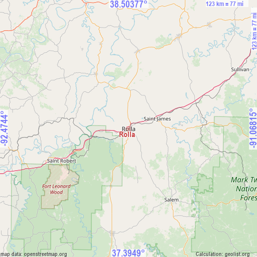
Rolla GPS coordinates[2]
37° 57' 5.148" North, 91° 46' 16.572" West
| Map corner | latitude | longitude |
|---|---|---|
| Upper-left | 38.50377°, | -92.4744° |
| Center: | 37.95143°, | -91.77127° |
| Lower-right: | 37.3949°, | -91.06815° |
| Map W x H: | 123.3×123.3 km | = 76.6×76.6mi |
| max Lat: | 71.29058° ⇑61.9% North |
| Rolla: | 37.95143° |
| min Lat: | ⇓38.1% South 19.06759° |
| min Long | Rolla | max Long |
| -171.73463° | -91.77127° | -66.98998° |
| W 36.4%⇐ | ⇒63.6% E |
Elevation
Elevation of Rolla is 342 m = 1122 ft, and this is 47.2 m = 155 ft above average elevation for this country.
| Max E: |
3189 m = 10463 ft | 21.3% |
| Rolla | 342 m 1122 ft | |
| Avg. | 294.8 m = 967 ft | |
Min E: |
-60 m = -197 ft | 78.7% |
See also: United States elevation on elevation.city.
Geographical zone
Rolla is located in North temperate zone (between Tropic of Cancer and the Arctic Circle). Distance of this Northern Tropic circle is 1613.9 km =1002.8 mi to South.| Distance of | km | miles | from Rolla |
|---|---|---|---|
| North Pole | 5787.3 | 3596.1 | to North |
| Arctic Circle | 3181.4 | 1976.8 | to North |
| Tropic Cancer | 1613.9 | 1002.8 | to South |
| Equator | 4219.8 | 2622.1 | to South |


Nearby cities:
15 places around Rolla: (largest is in red/bold)
• Belle
37.5 km =23.3 mi,  6°
6°
• Bland
40.8 km =25.4 mi,  17°
17°
• Crocker
43.2 km =26.8 mi,  269°
269°
• Cuba
34.5 km =21.4 mi,  68°
68°
• Dixon
28.6 km =17.8 mi,  279°
279°
• Doolittle
9.7 km =6 mi,  262°
262°
• Fort Leonard Wood
43.5 km =27 mi,  231°
231°
• Iberia
48.2 km =30 mi,  288°
288°
• Owensville
49.8 km =30.9 mi,  28°
28°
• Saint James
14.7 km =9.1 mi, 69°
• Saint Robert
38.2 km =23.7 mi,  248°
248°
• Salem
39.8 km =24.7 mi,  148°
148°
• Steelville
36.6 km =22.7 mi,  87°
87°
• Vienna
30.4 km =18.9 mi,  329°
329°
• Waynesville
40.1 km =24.9 mi, 250°
Sources, notices
• [Note1] Compared only with cities in United States existing in our database
• [Src1] Map data: © OpenStreetMap contributors (CC-BY-SA)
• [Src2] Other city data from geonames.org with taken over terms of usage.
• [Src3] Geographical zone / Annual Mean Temperature by Robert A. Rohde @ Wikipedia
