Ecru geodata
Ecru (Mississippi) is a populated place; located in United States in America/Chicago (GMT-5) time zone. With population of 966 people, there are 16523 cities with bigger population in this country. Compared to other cities in United States, 78.3% of cities are located further ↑North; 56.2% of cities are located further →East and 66.9% of cities have higher elevation than Ecru. Note1


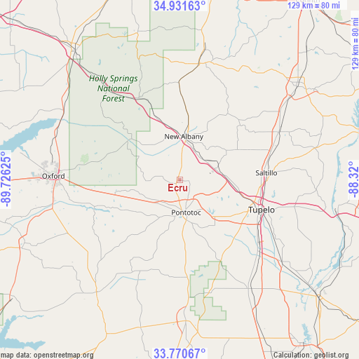
Ecru GPS coordinates[2]
34° 21' 11.376" North, 89° 1' 23.232" West
| Map corner | latitude | longitude |
|---|---|---|
| Upper-left | 34.93163°, | -89.72625° |
| Center: | 34.35316°, | -89.02312° |
| Lower-right: | 33.77067°, | -88.32° |
| Map W x H: | 129.1×129.1 km | = 80.2×80.2mi |
| max Lat: | 71.29058° ⇑78.3% North |
| Ecru: | 34.35316° |
| min Lat: | ⇓21.7% South 19.06759° |
| min Long | Ecru | max Long |
| -171.73463° | -89.02312° | -66.98998° |
| W 43.8%⇐ | ⇒56.2% E |
Elevation
Elevation of Ecru is 118 m = 387 ft, and this is 176.8 m = 580 ft below average elevation for this country.
| Max E: |
3189 m = 10463 ft | 66.9% |
| Avg. | 294.8 m = 967 ft | |
| Ecru | 118 m = 387 ft | |
Min E: |
-60 m = -197 ft | 33.1% |
See also: United States elevation on elevation.city.
Geographical zone
Ecru is located in North temperate zone (between Tropic of Cancer and the Arctic Circle). Distance of this Northern Tropic circle is 1213.8 km =754.2 mi to South.| Distance of | km | miles | from Ecru |
|---|---|---|---|
| North Pole | 6187.3 | 3844.6 | to North |
| Arctic Circle | 3581.5 | 2225.4 | to North |
| Tropic Cancer | 1213.8 | 754.2 | to South |
| Equator | 3819.7 | 2373.5 | to South |


Nearby cities:
15 places around Ecru: (largest is in red/bold)
• Algoma
19.7 km =12.2 mi,  182°
182°
• Blue Mountain
35.3 km =21.9 mi,  359°
359°
• Guntown
34.8 km =21.6 mi,  73°
73°
• Hickory Flat
32.9 km =20.4 mi,  332°
332°
• Houlka
35 km =21.7 mi, 179°
• Myrtle
24.5 km =15.2 mi,  338°
338°
• New Albany
15.8 km =9.8 mi,  5°
5°
• Plantersville
36.4 km =22.6 mi,  115°
115°
• Pontotoc
11.9 km =7.4 mi,  169°
169°
• Saltillo
31.4 km =19.5 mi,  85°
85°
• Shannon
38.9 km =24.2 mi,  132°
132°
• Sherman
16.7 km =10.4 mi, 87°
• Thaxton
15.1 km =9.4 mi,  250°
250°
• Tupelo
31.1 km =19.3 mi,  109°
109°
• Verona
33 km =20.5 mi, 122°
Sources, notices
• [Note1] Compared only with cities in United States existing in our database
• [Src1] Map data: © OpenStreetMap contributors (CC-BY-SA)
• [Src2] Other city data from geonames.org with taken over terms of usage.
• [Src3] Geographical zone / Annual Mean Temperature by Robert A. Rohde @ Wikipedia
