Guntown geodata
Guntown (Mississippi) is a populated place; located in United States in America/Chicago (GMT-5) time zone. With population of 2,608 people, there are 10377 cities with bigger population in this country. Compared to other cities in United States, 77.9% of cities are located further ↑North; 55.3% of cities are located further →East and 65.8% of cities have higher elevation than Guntown. Note1


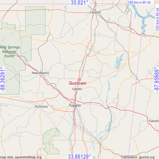
Guntown GPS coordinates[2]
34° 26' 35.376" North, 88° 39' 35.208" West
| Map corner | latitude | longitude |
|---|---|---|
| Upper-left | 35.021°, | -89.36291° |
| Center: | 34.44316°, | -88.65978° |
| Lower-right: | 33.86129°, | -87.95666° |
| Map W x H: | 128.9×128.9 km | = 80.1×80.1mi |
| max Lat: | 71.29058° ⇑77.9% North |
| Guntown: | 34.44316° |
| min Lat: | ⇓22.1% South 19.06759° |
| min Long | Guntown | max Long |
| -171.73463° | -88.65978° | -66.98998° |
| W 44.7%⇐ | ⇒55.3% E |
Elevation
Elevation of Guntown is 124 m = 407 ft, and this is 170.8 m = 560 ft below average elevation for this country.
| Max E: |
3189 m = 10463 ft | 65.8% |
| Avg. | 294.8 m = 967 ft | |
| Guntown | 124 m = 407 ft | |
Min E: |
-60 m = -197 ft | 34.2% |
See also: United States elevation on elevation.city.
Geographical zone
Guntown is located in North temperate zone (between Tropic of Cancer and the Arctic Circle). Distance of this Northern Tropic circle is 1223.8 km =760.4 mi to South.| Distance of | km | miles | from Guntown |
|---|---|---|---|
| North Pole | 6177.3 | 3838.4 | to North |
| Arctic Circle | 3571.5 | 2219.2 | to North |
| Tropic Cancer | 1223.8 | 760.4 | to South |
| Equator | 3829.7 | 2379.7 | to South |


Nearby cities:
15 places around Guntown: (largest is in red/bold)
• Baldwyn
7.7 km =4.8 mi,  16°
16°
• Booneville
25.4 km =15.8 mi, 19°
• Ecru
34.8 km =21.6 mi,  253°
253°
• Fulton
29.7 km =18.5 mi,  129°
129°
• Mantachie
20.4 km =12.7 mi, 130°
• Mooreville
21 km =13 mi,  158°
158°
• Nettleton
39.5 km =24.5 mi,  174°
174°
• New Albany
32.4 km =20.1 mi,  280°
280°
• Plantersville
25.5 km =15.8 mi,  180°
180°
• Pontotoc
37.9 km =23.5 mi,  235°
235°
• Saltillo
7.7 km =4.8 mi,  195°
195°
• Shannon
36.7 km =22.8 mi,  187°
187°
• Sherman
19.1 km =11.9 mi, 240°
• Tupelo
21 km =13 mi, 191°
• Verona
28.2 km =17.5 mi, 191°
Sources, notices
• [Note1] Compared only with cities in United States existing in our database
• [Src1] Map data: © OpenStreetMap contributors (CC-BY-SA)
• [Src2] Other city data from geonames.org with taken over terms of usage.
• [Src3] Geographical zone / Annual Mean Temperature by Robert A. Rohde @ Wikipedia
