Pontotoc geodata
Pontotoc (Mississippi) is a seat of a second-order administrative division; located in United States in America/Chicago (GMT-5) time zone. With population of 5,944 people, there are 6444 cities with bigger population in this country. Compared to other cities in United States, 78.7% of cities are located further ↑North; 56.1% of cities are located further →East and 60.1% of cities have higher elevation than Pontotoc. Note1


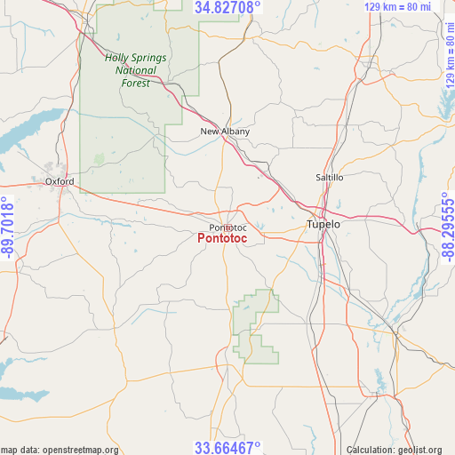
Pontotoc GPS coordinates[2]
34° 14' 52.368" North, 88° 59' 55.212" West
| Map corner | latitude | longitude |
|---|---|---|
| Upper-left | 34.82708°, | -89.7018° |
| Center: | 34.24788°, | -88.99867° |
| Lower-right: | 33.66467°, | -88.29555° |
| Map W x H: | 129.2×129.2 km | = 80.3×80.3mi |
| max Lat: | 71.29058° ⇑78.7% North |
| Pontotoc: | 34.24788° |
| min Lat: | ⇓21.3% South 19.06759° |
| min Long | Pontotoc | max Long |
| -171.73463° | -88.99867° | -66.98998° |
| W 43.9%⇐ | ⇒56.1% E |
Elevation
Elevation of Pontotoc is 154 m = 505 ft, and this is 140.8 m = 462 ft below average elevation for this country.
| Max E: |
3189 m = 10463 ft | 60.1% |
| Avg. | 294.8 m = 967 ft | |
| Pontotoc | 154 m = 505 ft | |
Min E: |
-60 m = -197 ft | 39.9% |
See also: United States elevation on elevation.city.
Geographical zone
Pontotoc is located in North temperate zone (between Tropic of Cancer and the Arctic Circle). Distance of this Northern Tropic circle is 1202.1 km =747 mi to South.| Distance of | km | miles | from Pontotoc |
|---|---|---|---|
| North Pole | 6199.1 | 3851.9 | to North |
| Arctic Circle | 3593.2 | 2232.7 | to North |
| Tropic Cancer | 1202.1 | 747 | to South |
| Equator | 3808 | 2366.2 | to South |


Nearby cities:
15 places around Pontotoc: (largest is in red/bold)
• Algoma
8.5 km =5.3 mi,  200°
200°
• Ecru
11.9 km =7.4 mi,  349°
349°
• Guntown
37.9 km =23.5 mi,  55°
55°
• Houlka
23.4 km =14.5 mi,  185°
185°
• Mooreville
38.8 km =24.1 mi,  86°
86°
• Myrtle
36.3 km =22.6 mi,  342°
342°
• New Albany
27.4 km =17 mi,  358°
358°
• Okolona
35.4 km =22 mi,  140°
140°
• Plantersville
31 km =19.3 mi,  97°
97°
• Saltillo
32.4 km =20.1 mi, 63°
• Shannon
30.2 km =18.8 mi,  119°
119°
• Sherman
19 km =11.8 mi,  49°
49°
• Thaxton
17.8 km =11.1 mi,  291°
291°
• Tupelo
27 km =16.8 mi, 87°
• Verona
26.3 km =16.3 mi, 103°
Sources, notices
• [Note1] Compared only with cities in United States existing in our database
• [Src1] Map data: © OpenStreetMap contributors (CC-BY-SA)
• [Src2] Other city data from geonames.org with taken over terms of usage.
• [Src3] Geographical zone / Annual Mean Temperature by Robert A. Rohde @ Wikipedia
