Kosciusko geodata
Kosciusko (Mississippi) is a seat of a second-order administrative division; located in United States in America/Chicago (GMT-5) time zone. With population of 7,187 people, there are 5707 cities with bigger population in this country. Compared to other cities in United States, 84.9% of cities are located further ↑North; 57.8% of cities are located further →East and 61.1% of cities have higher elevation than Kosciusko. Note1


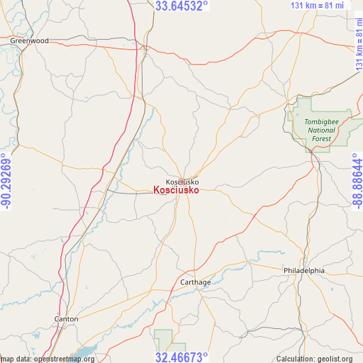
Kosciusko GPS coordinates[2]
33° 3' 28.8" North, 89° 35' 22.416" West
| Map corner | latitude | longitude |
|---|---|---|
| Upper-left | 33.64532°, | -90.29269° |
| Center: | 33.058°, | -89.58956° |
| Lower-right: | 32.46673°, | -88.88644° |
| Map W x H: | 131×131 km | = 81.4×81.4mi |
| max Lat: | 71.29058° ⇑84.9% North |
| Kosciusko: | 33.058° |
| min Lat: | ⇓15.1% South 19.06759° |
| min Long | Kosciusko | max Long |
| -171.73463° | -89.58956° | -66.98998° |
| W 42.2%⇐ | ⇒57.8% E |
Elevation
Elevation of Kosciusko is 149 m = 489 ft, and this is 145.8 m = 478 ft below average elevation for this country.
| Max E: |
3189 m = 10463 ft | 61.1% |
| Avg. | 294.8 m = 967 ft | |
| Kosciusko | 149 m = 489 ft | |
Min E: |
-60 m = -197 ft | 38.9% |
See also: United States elevation on elevation.city.
Geographical zone
Kosciusko is located in North temperate zone (between Tropic of Cancer and the Arctic Circle). Distance of this Northern Tropic circle is 1069.8 km =664.7 mi to South.| Distance of | km | miles | from Kosciusko |
|---|---|---|---|
| North Pole | 6331.4 | 3934.1 | to North |
| Arctic Circle | 3725.5 | 2314.9 | to North |
| Tropic Cancer | 1069.8 | 664.7 | to South |
| Equator | 3675.7 | 2284 | to South |


Nearby cities:
15 places around Kosciusko: (largest is in red/bold)
• Ackerman
47.8 km =29.7 mi,  54°
54°
• Carthage
36.5 km =22.7 mi,  172°
172°
• Coldwater
51.8 km =32.2 mi,  137°
137°
• Durant
24.8 km =15.4 mi,  274°
274°
• Goodman
31.6 km =19.6 mi,  252°
252°
• Kilmichael
42.9 km =26.7 mi,  2°
2°
• Lexington
43.6 km =27.1 mi,  278°
278°
• Louisville
50.3 km =31.3 mi,  81°
81°
• Pearl River
45.5 km =28.3 mi,  132°
132°
• Pickens
40.6 km =25.2 mi,  241°
241°
• Redwater
32.8 km =20.4 mi, 171°
• Standing Pine
45.1 km =28 mi,  161°
161°
• Vaiden
33.6 km =20.9 mi,  335°
335°
• Walnut Grove
53.4 km =33.2 mi, 166°
• Winona
48.9 km =30.4 mi, 344°
Sources, notices
• [Note1] Compared only with cities in United States existing in our database
• [Src1] Map data: © OpenStreetMap contributors (CC-BY-SA)
• [Src2] Other city data from geonames.org with taken over terms of usage.
• [Src3] Geographical zone / Annual Mean Temperature by Robert A. Rohde @ Wikipedia
