Louisville geodata
Louisville (Mississippi) is a seat of a second-order administrative division; located in United States in America/Chicago (GMT-5) time zone. With population of 6,314 people, there are 6213 cities with bigger population in this country. Compared to other cities in United States, 84.7% of cities are located further ↑North; 56.3% of cities are located further →East and 56% of cities have higher elevation than Louisville. Note1


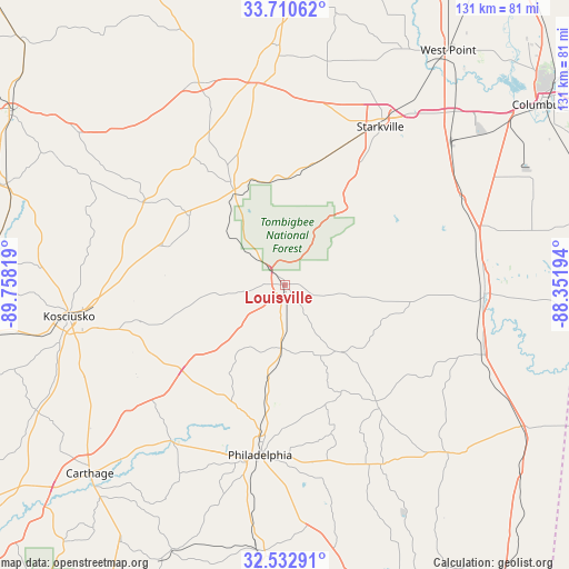
Louisville GPS coordinates[2]
33° 7' 25.464" North, 89° 3' 18.216" West
| Map corner | latitude | longitude |
|---|---|---|
| Upper-left | 33.71062°, | -89.75819° |
| Center: | 33.12374°, | -89.05506° |
| Lower-right: | 32.53291°, | -88.35194° |
| Map W x H: | 130.9×130.9 km | = 81.3×81.3mi |
| max Lat: | 71.29058° ⇑84.7% North |
| Louisville: | 33.12374° |
| min Lat: | ⇓15.3% South 19.06759° |
| min Long | Louisville | max Long |
| -171.73463° | -89.05506° | -66.98998° |
| W 43.7%⇐ | ⇒56.3% E |
Elevation
Elevation of Louisville is 176 m = 577 ft, and this is 118.8 m = 390 ft below average elevation for this country.
| Max E: |
3189 m = 10463 ft | 56% |
| Avg. | 294.8 m = 967 ft | |
| Louisville | 176 m = 577 ft | |
Min E: |
-60 m = -197 ft | 44% |
See also: United States elevation on elevation.city.
Geographical zone
Louisville is located in North temperate zone (between Tropic of Cancer and the Arctic Circle). Distance of this Northern Tropic circle is 1077.1 km =669.3 mi to South.| Distance of | km | miles | from Louisville |
|---|---|---|---|
| North Pole | 6324 | 3929.6 | to North |
| Arctic Circle | 3718.2 | 2310.4 | to North |
| Tropic Cancer | 1077.1 | 669.3 | to South |
| Equator | 3683 | 2288.5 | to South |


Nearby cities:
15 places around Louisville: (largest is in red/bold)
• Ackerman
23.4 km =14.5 mi,  332°
332°
• Bogue Chitto
34.5 km =21.4 mi,  160°
160°
• Brooksville
45.7 km =28.4 mi,  74°
74°
• Coldwater
47.8 km =29.7 mi,  198°
198°
• Crawford
45.5 km =28.3 mi,  64°
64°
• Deemer
42.5 km =26.4 mi,  187°
187°
• Eupora
50.4 km =31.3 mi,  336°
336°
• Kosciusko
50.3 km =31.3 mi,  261°
261°
• Maben
48.1 km =29.9 mi,  356°
356°
• Macon
46.1 km =28.6 mi,  92°
92°
• Mathiston
46.7 km =29 mi,  352°
352°
• Pearl River
41.1 km =25.5 mi, 203°
• Philadelphia
39.6 km =24.6 mi, 188°
• Starkville
42.4 km =26.3 mi,  31°
31°
• Tucker
46.4 km =28.8 mi,  179°
179°
Sources, notices
• [Note1] Compared only with cities in United States existing in our database
• [Src1] Map data: © OpenStreetMap contributors (CC-BY-SA)
• [Src2] Other city data from geonames.org with taken over terms of usage.
• [Src3] Geographical zone / Annual Mean Temperature by Robert A. Rohde @ Wikipedia
