Laurel geodata
Laurel (Mississippi) is a populated place; located in United States in America/Chicago (GMT-5) time zone. With population of 18,837 people, there are 2677 cities with bigger population in this country. Compared to other cities in United States, 89.2% of cities are located further ↑North; 56.5% of cities are located further →East and 72% of cities have higher elevation than Laurel. Note1


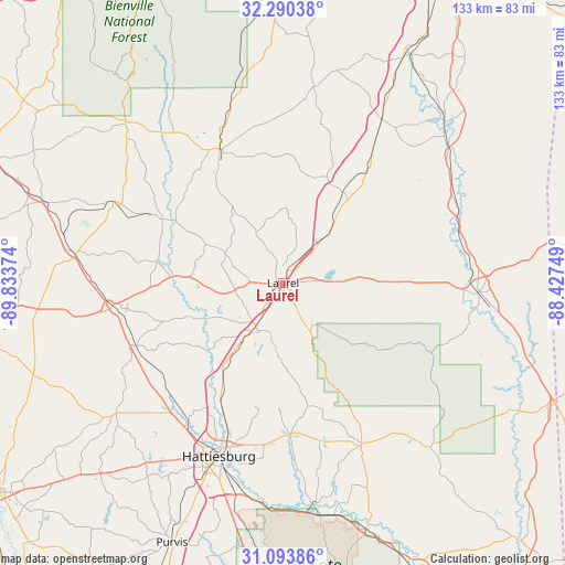
Laurel GPS coordinates[2]
31° 41' 38.58" North, 89° 7' 50.196" West
| Map corner | latitude | longitude |
|---|---|---|
| Upper-left | 32.29038°, | -89.83374° |
| Center: | 31.69405°, | -89.13061° |
| Lower-right: | 31.09386°, | -88.42749° |
| Map W x H: | 133×133 km | = 82.6×82.6mi |
| max Lat: | 71.29058° ⇑89.2% North |
| Laurel: | 31.69405° |
| min Lat: | ⇓10.8% South 19.06759° |
| min Long | Laurel | max Long |
| -171.73463° | -89.13061° | -66.98998° |
| W 43.5%⇐ | ⇒56.5% E |
Elevation
Elevation of Laurel is 89 m = 292 ft, and this is 205.8 m = 675 ft below average elevation for this country.
| Max E: |
3189 m = 10463 ft | 72% |
| Avg. | 294.8 m = 967 ft | |
| Laurel | 89 m = 292 ft | |
Min E: |
-60 m = -197 ft | 28% |
See also: United States elevation on elevation.city.
Geographical zone
Laurel is located in North temperate zone (between Tropic of Cancer and the Arctic Circle). Distance of this Northern Tropic circle is 918.1 km =570.5 mi to South.| Distance of | km | miles | from Laurel |
|---|---|---|---|
| North Pole | 6483 | 4028.3 | to North |
| Arctic Circle | 3877.1 | 2409.1 | to North |
| Tropic Cancer | 918.1 | 570.5 | to South |
| Equator | 3524 | 2189.7 | to South |


Nearby cities:
15 places around Laurel: (largest is in red/bold)
• Arnold Line
46.1 km =28.6 mi,  209°
209°
• Bay Springs
35 km =21.7 mi,  334°
334°
• Collins
40.6 km =25.2 mi,  262°
262°
• Ellisville
11.7 km =7.3 mi, 211°
• Glendale
40.2 km =25 mi,  204°
204°
• Hattiesburg
43.5 km =27 mi, 200°
• Heidelberg
25.5 km =15.8 mi,  32°
32°
• Petal
40.5 km =25.2 mi, 197°
• Rawls Springs
41.6 km =25.8 mi, 213°
• Richton
42.4 km =26.3 mi,  154°
154°
• Sandersville
13.7 km =8.5 mi,  41°
41°
• Sharon
11 km =6.8 mi,  15°
15°
• Taylorsville
31.9 km =19.8 mi,  298°
298°
• Waynesboro
45.9 km =28.5 mi,  92°
92°
• West Hattiesburg
47.7 km =29.6 mi, 209°
Sources, notices
• [Note1] Compared only with cities in United States existing in our database
• [Src1] Map data: © OpenStreetMap contributors (CC-BY-SA)
• [Src2] Other city data from geonames.org with taken over terms of usage.
• [Src3] Geographical zone / Annual Mean Temperature by Robert A. Rohde @ Wikipedia
