Hattiesburg geodata
Hattiesburg (Mississippi) is a seat of a second-order administrative division; located in United States in America/Chicago (GMT-5) time zone. With population of 46,805 people, there are 1027 cities with bigger population in this country. Compared to other cities in United States, 90% of cities are located further ↑North; 57% of cities are located further →East and 78.4% of cities have higher elevation than Hattiesburg. Note1


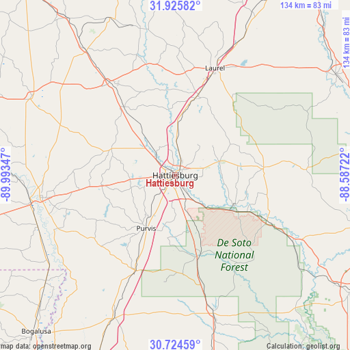
Hattiesburg GPS coordinates[2]
31° 19' 37.632" North, 89° 17' 25.224" West
| Map corner | latitude | longitude |
|---|---|---|
| Upper-left | 31.92582°, | -89.99347° |
| Center: | 31.32712°, | -89.29034° |
| Lower-right: | 30.72459°, | -88.58722° |
| Map W x H: | 133.6×133.6 km | = 83×83mi |
| max Lat: | 71.29058° ⇑90% North |
| Hattiesburg: | 31.32712° |
| min Lat: | ⇓10% South 19.06759° |
| min Long | Hattiesburg | max Long |
| -171.73463° | -89.29034° | -66.98998° |
| W 43%⇐ | ⇒57% E |
Elevation
Elevation of Hattiesburg is 54 m = 177 ft, and this is 240.8 m = 790 ft below average elevation for this country.
| Max E: |
3189 m = 10463 ft | 78.4% |
| Avg. | 294.8 m = 967 ft | |
| Hattiesburg | 54 m = 177 ft | |
Min E: |
-60 m = -197 ft | 21.6% |
See also: Hattiesburg elevation on elevation.city.
Geographical zone
Hattiesburg is located in North temperate zone (between Tropic of Cancer and the Arctic Circle). Distance of this Northern Tropic circle is 877.3 km =545.1 mi to South.| Distance of | km | miles | from Hattiesburg |
|---|---|---|---|
| North Pole | 6523.8 | 4053.7 | to North |
| Arctic Circle | 3917.9 | 2434.5 | to North |
| Tropic Cancer | 877.3 | 545.1 | to South |
| Equator | 3483.2 | 2164.4 | to South |


Nearby cities:
15 places around Hattiesburg: (largest is in red/bold)
• Arnold Line
7.9 km =4.9 mi,  276°
276°
• Beaumont
39.3 km =24.4 mi,  116°
116°
• Collins
43.4 km =27 mi,  324°
324°
• Columbia
52.7 km =32.7 mi,  260°
260°
• Ellisville
32.1 km =19.9 mi,  16°
16°
• Glendale
4.4 km =2.7 mi,  340°
340°
• Laurel
43.5 km =27 mi, 20°
• Lumberton
39.4 km =24.5 mi,  203°
203°
• New Augusta
27.8 km =17.3 mi, 119°
• Petal
3.6 km =2.2 mi,  53°
53°
• Purvis
23.4 km =14.5 mi,  209°
209°
• Rawls Springs
9.7 km =6 mi,  307°
307°
• Richton
33.4 km =20.8 mi,  85°
85°
• Sumrall
25.9 km =16.1 mi,  292°
292°
• West Hattiesburg
8.1 km =5 mi, 263°
Sources, notices
• [Note1] Compared only with cities in United States existing in our database
• [Src1] Map data: © OpenStreetMap contributors (CC-BY-SA)
• [Src2] Other city data from geonames.org with taken over terms of usage.
• [Src3] Geographical zone / Annual Mean Temperature by Robert A. Rohde @ Wikipedia
