Philadelphia geodata
Philadelphia (Mississippi) is a seat of a second-order administrative division; located in United States in America/Chicago (GMT-5) time zone. With population of 7,391 people, there are 5598 cities with bigger population in this country. Compared to other cities in United States, 86.1% of cities are located further ↑North; 56.5% of cities are located further →East and 65% of cities have higher elevation than Philadelphia. Note1


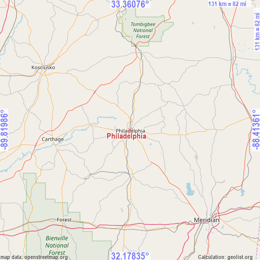
Philadelphia GPS coordinates[2]
32° 46' 17.472" North, 89° 7' 0.228" West
| Map corner | latitude | longitude |
|---|---|---|
| Upper-left | 33.36076°, | -89.81986° |
| Center: | 32.77152°, | -89.11673° |
| Lower-right: | 32.17835°, | -88.41361° |
| Map W x H: | 131.5×131.5 km | = 81.7×81.7mi |
| max Lat: | 71.29058° ⇑86.1% North |
| Philadelphia: | 32.77152° |
| min Lat: | ⇓13.9% South 19.06759° |
| min Long | Philadelphia | max Long |
| -171.73463° | -89.11673° | -66.98998° |
| W 43.5%⇐ | ⇒56.5% E |
Elevation
Elevation of Philadelphia is 128 m = 420 ft, and this is 166.8 m = 547 ft below average elevation for this country.
| Max E: |
3189 m = 10463 ft | 65% |
| Avg. | 294.8 m = 967 ft | |
| Philadelphia | 128 m = 420 ft | |
Min E: |
-60 m = -197 ft | 35% |
See also: United States elevation on elevation.city.
Geographical zone
Philadelphia is located in North temperate zone (between Tropic of Cancer and the Arctic Circle). Distance of this Northern Tropic circle is 1037.9 km =644.9 mi to South.| Distance of | km | miles | from Philadelphia |
|---|---|---|---|
| North Pole | 6363.2 | 3953.9 | to North |
| Arctic Circle | 3757.3 | 2334.7 | to North |
| Tropic Cancer | 1037.9 | 644.9 | to South |
| Equator | 3643.9 | 2264.2 | to South |


Nearby cities:
15 places around Philadelphia: (largest is in red/bold)
• Bogue Chitto
18.5 km =11.5 mi,  69°
69°
• Carthage
39.5 km =24.5 mi,  263°
263°
• Coldwater
11.1 km =6.9 mi,  235°
235°
• Collinsville
39.6 km =24.6 mi,  140°
140°
• Conehatta
39 km =24.2 mi,  203°
203°
• De Kalb
43.6 km =27.1 mi,  90°
90°
• Decatur
37 km =23 mi,  178°
178°
• Deemer
2.9 km =1.8 mi, 182°
• Louisville
39.6 km =24.6 mi,  8°
8°
• Pearl River
10.5 km =6.5 mi,  277°
277°
• Redwater
39.3 km =24.4 mi,  269°
269°
• Standing Pine
31.6 km =19.6 mi,  249°
249°
• Tucker
9.3 km =5.8 mi, 140°
• Union
22.2 km =13.8 mi, 181°
• Walnut Grove
37.8 km =23.5 mi, 237°
Sources, notices
• [Note1] Compared only with cities in United States existing in our database
• [Src1] Map data: © OpenStreetMap contributors (CC-BY-SA)
• [Src2] Other city data from geonames.org with taken over terms of usage.
• [Src3] Geographical zone / Annual Mean Temperature by Robert A. Rohde @ Wikipedia
