Tchula geodata
Tchula (Mississippi) is a populated place; located in United States in America/Chicago (GMT-5) time zone. With population of 2,006 people, there are 11926 cities with bigger population in this country. Compared to other cities in United States, 84.4% of cities are located further ↑North; 59.7% of cities are located further →East and 82.1% of cities have higher elevation than Tchula. Note1


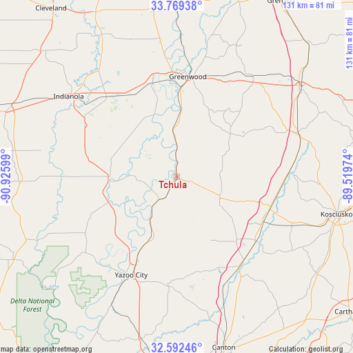
Tchula GPS coordinates[2]
33° 10' 58.44" North, 90° 13' 22.296" West
| Map corner | latitude | longitude |
|---|---|---|
| Upper-left | 33.76938°, | -90.92599° |
| Center: | 33.1829°, | -90.22286° |
| Lower-right: | 32.59246°, | -89.51974° |
| Map W x H: | 130.9×130.9 km | = 81.3×81.3mi |
| max Lat: | 71.29058° ⇑84.4% North |
| Tchula: | 33.1829° |
| min Lat: | ⇓15.6% South 19.06759° |
| min Long | Tchula | max Long |
| -171.73463° | -90.22286° | -66.98998° |
| W 40.3%⇐ | ⇒59.7% E |
Elevation
Elevation of Tchula is 38 m = 125 ft, and this is 256.8 m = 843 ft below average elevation for this country.
| Max E: |
3189 m = 10463 ft | 82.1% |
| Avg. | 294.8 m = 967 ft | |
| Tchula | 38 m = 125 ft | |
Min E: |
-60 m = -197 ft | 17.9% |
See also: United States elevation on elevation.city.
Geographical zone
Tchula is located in North temperate zone (between Tropic of Cancer and the Arctic Circle). Distance of this Northern Tropic circle is 1083.7 km =673.4 mi to South.| Distance of | km | miles | from Tchula |
|---|---|---|---|
| North Pole | 6317.5 | 3925.5 | to North |
| Arctic Circle | 3711.6 | 2306.3 | to North |
| Tropic Cancer | 1083.7 | 673.4 | to South |
| Equator | 3689.6 | 2292.6 | to South |


Nearby cities:
15 places around Tchula: (largest is in red/bold)
• Belzoni
24.8 km =15.4 mi,  270°
270°
• Carrollton
45.8 km =28.5 mi,  37°
37°
• Durant
36.3 km =22.6 mi,  109°
109°
• Goodman
37.4 km =23.2 mi,  129°
129°
• Greenwood
37.3 km =23.2 mi,  6°
6°
• Inverness
39.3 km =24.4 mi,  298°
298°
• Isola
35.5 km =22.1 mi,  284°
284°
• Itta Bena
35.9 km =22.3 mi,  345°
345°
• Lexington
17.6 km =10.9 mi,  116°
116°
• Moorhead
39.7 km =24.7 mi,  318°
318°
• Pickens
40.7 km =25.3 mi,  144°
144°
• Sidon
25.1 km =15.6 mi,  4°
4°
• Sunflower
49.5 km =30.8 mi, 323°
• Vaiden
47.8 km =29.7 mi,  69°
69°
• Yazoo City
40.2 km =25 mi,  205°
205°
Sources, notices
• [Note1] Compared only with cities in United States existing in our database
• [Src1] Map data: © OpenStreetMap contributors (CC-BY-SA)
• [Src2] Other city data from geonames.org with taken over terms of usage.
• [Src3] Geographical zone / Annual Mean Temperature by Robert A. Rohde @ Wikipedia
