Sidon geodata
Sidon (Mississippi) is a populated place; located in United States in America/Chicago (GMT-5) time zone. With population of 509 people, there are 20770 cities with bigger population in this country. Compared to other cities in United States, 83.6% of cities are located further ↑North; 59.7% of cities are located further →East and 82.3% of cities have higher elevation than Sidon. Note1


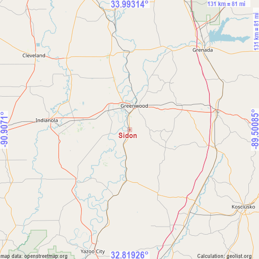
Sidon GPS coordinates[2]
33° 24' 29.448" North, 90° 12' 14.292" West
| Map corner | latitude | longitude |
|---|---|---|
| Upper-left | 33.99314°, | -90.9071° |
| Center: | 33.40818°, | -90.20397° |
| Lower-right: | 32.81926°, | -89.50085° |
| Map W x H: | 130.5×130.5 km | = 81.1×81.1mi |
| max Lat: | 71.29058° ⇑83.6% North |
| Sidon: | 33.40818° |
| min Lat: | ⇓16.4% South 19.06759° |
| min Long | Sidon | max Long |
| -171.73463° | -90.20397° | -66.98998° |
| W 40.3%⇐ | ⇒59.7% E |
Elevation
Elevation of Sidon is 37 m = 121 ft, and this is 257.8 m = 846 ft below average elevation for this country.
| Max E: |
3189 m = 10463 ft | 82.3% |
| Avg. | 294.8 m = 967 ft | |
| Sidon | 37 m = 121 ft | |
Min E: |
-60 m = -197 ft | 17.7% |
See also: United States elevation on elevation.city.
Geographical zone
Sidon is located in North temperate zone (between Tropic of Cancer and the Arctic Circle). Distance of this Northern Tropic circle is 1108.7 km =688.9 mi to South.| Distance of | km | miles | from Sidon |
|---|---|---|---|
| North Pole | 6292.4 | 3909.9 | to North |
| Arctic Circle | 3686.5 | 2290.7 | to North |
| Tropic Cancer | 1108.7 | 688.9 | to South |
| Equator | 3714.6 | 2308.1 | to South |


Nearby cities:
15 places around Sidon: (largest is in red/bold)
• Belzoni
36.4 km =22.6 mi,  226°
226°
• Carrollton
28.6 km =17.8 mi,  67°
67°
• Greenwood
12.2 km =7.6 mi,  10°
10°
• Holcomb
44.6 km =27.7 mi,  28°
28°
• Indianola
42.1 km =26.2 mi,  276°
276°
• Inverness
36.6 km =22.7 mi,  260°
260°
• Isola
39.6 km =24.6 mi,  245°
245°
• Itta Bena
14.5 km =9 mi,  311°
311°
• Lexington
35.7 km =22.2 mi,  156°
156°
• Moorhead
28.4 km =17.6 mi, 279°
• Ruleville
47.8 km =29.7 mi,  317°
317°
• Sunflower
34.3 km =21.3 mi,  295°
295°
• Tchula
25.1 km =15.6 mi,  184°
184°
• Vaiden
43.8 km =27.2 mi,  101°
101°
• Winona
44.9 km =27.9 mi,  79°
79°
Sources, notices
• [Note1] Compared only with cities in United States existing in our database
• [Src1] Map data: © OpenStreetMap contributors (CC-BY-SA)
• [Src2] Other city data from geonames.org with taken over terms of usage.
• [Src3] Geographical zone / Annual Mean Temperature by Robert A. Rohde @ Wikipedia
