Carrollton geodata
Carrollton (Mississippi) is a seat of a second-order administrative division; located in United States in America/Chicago (GMT-5) time zone. With population of 182 people, there are 21016 cities with bigger population in this country. Compared to other cities in United States, 83.1% of cities are located further ↑North; 58.8% of cities are located further →East and 72.1% of cities have higher elevation than Carrollton. Note1


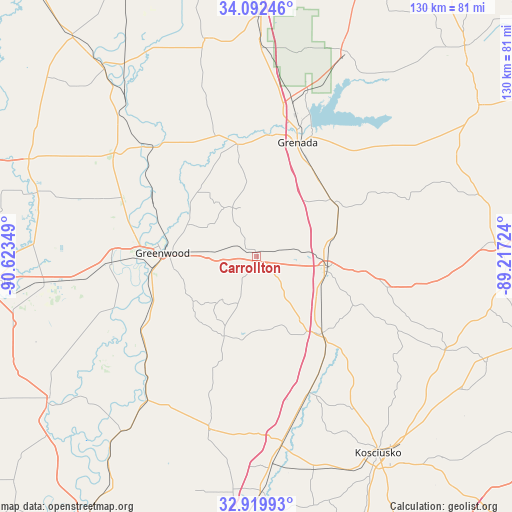
Carrollton GPS coordinates[2]
33° 30' 29.448" North, 89° 55' 13.296" West
| Map corner | latitude | longitude |
|---|---|---|
| Upper-left | 34.09246°, | -90.62349° |
| Center: | 33.50818°, | -89.92036° |
| Lower-right: | 32.91993°, | -89.21724° |
| Map W x H: | 130.4×130.4 km | = 81×81mi |
| max Lat: | 71.29058° ⇑83.1% North |
| Carrollton: | 33.50818° |
| min Lat: | ⇓16.9% South 19.06759° |
| min Long | Carrollton | max Long |
| -171.73463° | -89.92036° | -66.98998° |
| W 41.2%⇐ | ⇒58.8% E |
Elevation
Elevation of Carrollton is 88 m = 289 ft, and this is 206.8 m = 678 ft below average elevation for this country.
| Max E: |
3189 m = 10463 ft | 72.1% |
| Avg. | 294.8 m = 967 ft | |
| Carrollton | 88 m = 289 ft | |
Min E: |
-60 m = -197 ft | 27.9% |
See also: United States elevation on elevation.city.
Geographical zone
Carrollton is located in North temperate zone (between Tropic of Cancer and the Arctic Circle). Distance of this Northern Tropic circle is 1119.8 km =695.8 mi to South.| Distance of | km | miles | from Carrollton |
|---|---|---|---|
| North Pole | 6281.3 | 3903 | to North |
| Arctic Circle | 3675.4 | 2283.8 | to North |
| Tropic Cancer | 1119.8 | 695.8 | to South |
| Equator | 3725.8 | 2315.1 | to South |


Nearby cities:
15 places around Carrollton: (largest is in red/bold)
• Coffeeville
56.8 km =35.3 mi,  23°
23°
• Duck Hill
23.8 km =14.8 mi,  54°
54°
• Durant
48.5 km =30.1 mi,  172°
172°
• Elliott
25.1 km =15.6 mi,  39°
39°
• Greenwood
24 km =14.9 mi,  272°
272°
• Grenada
30.8 km =19.1 mi, 19°
• Holcomb
28.6 km =17.8 mi,  349°
349°
• Itta Bena
37.1 km =23.1 mi, 267°
• Kilmichael
33.1 km =20.6 mi,  102°
102°
• Lexington
45.6 km =28.3 mi,  195°
195°
• Moorhead
54.7 km =34 mi,  263°
263°
• Sidon
28.6 km =17.8 mi,  247°
247°
• Tchula
45.8 km =28.5 mi,  217°
217°
• Vaiden
25.7 km =16 mi,  139°
139°
• Winona
18.1 km =11.2 mi, 99°
Sources, notices
• [Note1] Compared only with cities in United States existing in our database
• [Src1] Map data: © OpenStreetMap contributors (CC-BY-SA)
• [Src2] Other city data from geonames.org with taken over terms of usage.
• [Src3] Geographical zone / Annual Mean Temperature by Robert A. Rohde @ Wikipedia
