Aurora geodata
Aurora (North Carolina) is a populated place; located in United States in America/New_York (GMT-4) time zone. With population of 522 people, there are 20606 cities with bigger population in this country. Compared to other cities in United States, 73.6% of cities are located further ↑North; 81.6% of cities are located further ←West and 97.4% of cities have higher elevation than Aurora. Note1
Administrative division(s):
- Level 1: North Carolina
- Level 2: Beaufort County
- Level 3: Township of Richland


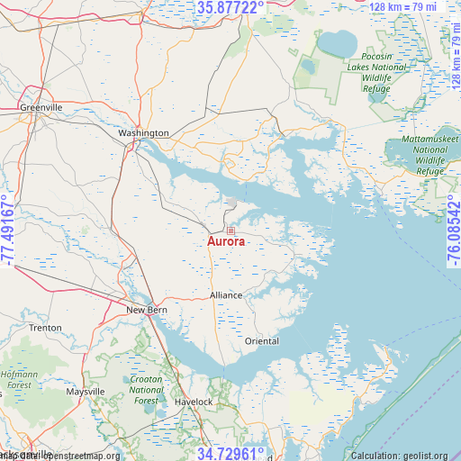
Aurora GPS coordinates[2]
35° 18' 19.62" North, 76° 47' 18.744" West
| Map corner | latitude | longitude |
|---|---|---|
| Upper-left | 35.87722°, | -77.49167° |
| Center: | 35.30545°, | -76.78854° |
| Lower-right: | 34.72961°, | -76.08542° |
| Map W x H: | 127.6×127.6 km | = 79.3×79.3mi |
| max Lat: | 71.29058° ⇑73.6% North |
| Aurora: | 35.30545° |
| min Lat: | ⇓26.4% South 19.06759° |
| min Long | Aurora | max Long |
| -171.73463° | -76.78854° | -66.98998° |
| W 81.6%⇐ | ⇒18.4% E |
Elevation
Elevation of Aurora is 6 m = 20 ft, and this is 288.8 m = 948 ft below average elevation for this country.
| Max E: |
3189 m = 10463 ft | 97.4% |
| Avg. | 294.8 m = 967 ft | |
| Aurora | 6 m = 20 ft | |
Min E: |
-60 m = -197 ft | 2.6% |
See also: United States elevation on elevation.city.
Geographical zone
Aurora is located in North temperate zone (between Tropic of Cancer and the Arctic Circle). Distance of this Northern Tropic circle is 1319.7 km =820 mi to South.| Distance of | km | miles | from Aurora |
|---|---|---|---|
| North Pole | 6081.5 | 3778.9 | to North |
| Arctic Circle | 3475.6 | 2159.6 | to North |
| Tropic Cancer | 1319.7 | 820 | to South |
| Equator | 3925.6 | 2439.3 | to South |


Nearby cities:
15 places around Aurora: (largest is in red/bold)
• Alliance
17.9 km =11.1 mi,  183°
183°
• Arapahoe
31.3 km =19.4 mi,  186°
186°
• Bayboro
18.1 km =11.2 mi,  174°
174°
• Belhaven
30.1 km =18.7 mi,  29°
29°
• Brices Creek
38.8 km =24.1 mi,  224°
224°
• Chocowinity
36.5 km =22.7 mi,  309°
309°
• Fairfield Harbour
30 km =18.6 mi,  211°
211°
• Grantsboro
19 km =11.8 mi, 194°
• James City
32.9 km =20.4 mi, 222°
• New Bern
31.9 km =19.8 mi,  226°
226°
• Oriental
31.7 km =19.7 mi,  164°
164°
• River Road
28.9 km =18 mi,  320°
320°
• Trent Woods
36.7 km =22.8 mi, 227°
• Vanceboro
33.2 km =20.6 mi,  270°
270°
• Washington
35.9 km =22.3 mi, 318°
Sources, notices
• [Note1] Compared only with cities in United States existing in our database
• [Src1] Map data: © OpenStreetMap contributors (CC-BY-SA)
• [Src2] Other city data from geonames.org with taken over terms of usage.
• [Src3] Geographical zone / Annual Mean Temperature by Robert A. Rohde @ Wikipedia
