Battleboro geodata
Battleboro (North Carolina) is a populated place; located in United States in America/New_York (GMT-4) time zone. With population of 527 people, there are 20547 cities with bigger population in this country. Compared to other cities in United States, 70.2% of cities are located further ↑North; 78.3% of cities are located further ←West and 82.1% of cities have higher elevation than Battleboro. Note1
Administrative division(s):
- Level 1: North Carolina
- Level 2: Nash County
- Level 3: Township of South Whitakers


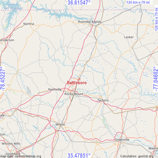
Battleboro GPS coordinates[2]
36° 2' 56.544" North, 77° 44' 56.904" West
| Map corner | latitude | longitude |
|---|---|---|
| Upper-left | 36.61547°, | -78.45227° |
| Center: | 36.04904°, | -77.74914° |
| Lower-right: | 35.47851°, | -77.04602° |
| Map W x H: | 126.4×126.4 km | = 78.5×78.5mi |
| max Lat: | 71.29058° ⇑70.2% North |
| Battleboro: | 36.04904° |
| min Lat: | ⇓29.8% South 19.06759° |
| min Long | Battleboro | max Long |
| -171.73463° | -77.74914° | -66.98998° |
| W 78.3%⇐ | ⇒21.7% E |
Elevation
Elevation of Battleboro is 38 m = 125 ft, and this is 256.8 m = 843 ft below average elevation for this country.
| Max E: |
3189 m = 10463 ft | 82.1% |
| Avg. | 294.8 m = 967 ft | |
| Battleboro | 38 m = 125 ft | |
Min E: |
-60 m = -197 ft | 17.9% |
See also: United States elevation on elevation.city.
Geographical zone
Battleboro is located in North temperate zone (between Tropic of Cancer and the Arctic Circle). Distance of this Northern Tropic circle is 1402.4 km =871.4 mi to South.| Distance of | km | miles | from Battleboro |
|---|---|---|---|
| North Pole | 5998.8 | 3727.5 | to North |
| Arctic Circle | 3392.9 | 2108.2 | to North |
| Tropic Cancer | 1402.4 | 871.4 | to South |
| Equator | 4008.3 | 2490.6 | to South |


Nearby cities:
15 places around Battleboro: (largest is in red/bold)
• Dortches
10.6 km =6.6 mi,  246°
246°
• Elm City
28.9 km =18 mi,  200°
200°
• Enfield
16.4 km =10.2 mi,  26°
26°
• Halifax
34.2 km =21.3 mi,  24°
24°
• Hollister
28.5 km =17.7 mi,  323°
323°
• Nashville
21.2 km =13.2 mi, 246°
• Pinetops
30.7 km =19.1 mi,  160°
160°
• Princeville
26.4 km =16.4 mi,  132°
132°
• Red Oak
14.2 km =8.8 mi,  265°
265°
• Rocky Mount
12.9 km =8 mi, 196°
• Scotland Neck
30.9 km =19.2 mi,  73°
73°
• Sharpsburg
21.5 km =13.4 mi, 199°
• Spring Hope
34.6 km =21.5 mi, 250°
• Tarboro
25.6 km =15.9 mi, 131°
• Whitakers
7.1 km =4.4 mi, 27°
Sources, notices
• [Note1] Compared only with cities in United States existing in our database
• [Src1] Map data: © OpenStreetMap contributors (CC-BY-SA)
• [Src2] Other city data from geonames.org with taken over terms of usage.
• [Src3] Geographical zone / Annual Mean Temperature by Robert A. Rohde @ Wikipedia
