Red Oak geodata
Red Oak (North Carolina) is a populated place; located in United States in America/New_York (GMT-4) time zone. With population of 3,424 people, there are 8955 cities with bigger population in this country. Compared to other cities in United States, 70.3% of cities are located further ↑North; 78% of cities are located further ←West and 76.5% of cities have higher elevation than Red Oak. Note1
Administrative division(s):
- Level 1: North Carolina
- Level 2: Nash County
- Level 3: Township of Red Oak


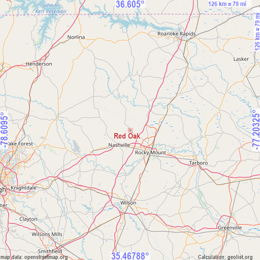
Red Oak GPS coordinates[2]
36° 2' 18.564" North, 77° 54' 22.932" West
| Map corner | latitude | longitude |
|---|---|---|
| Upper-left | 36.605°, | -78.6095° |
| Center: | 36.03849°, | -77.90637° |
| Lower-right: | 35.46788°, | -77.20325° |
| Map W x H: | 126.4×126.4 km | = 78.5×78.5mi |
| max Lat: | 71.29058° ⇑70.3% North |
| Red Oak: | 36.03849° |
| min Lat: | ⇓29.7% South 19.06759° |
| min Long | Red Oak | max Long |
| -171.73463° | -77.90637° | -66.98998° |
| W 78%⇐ | ⇒22% E |
Elevation
Elevation of Red Oak is 63 m = 207 ft, and this is 231.8 m = 760 ft below average elevation for this country.
| Max E: |
3189 m = 10463 ft | 76.5% |
| Avg. | 294.8 m = 967 ft | |
| Red Oak | 63 m = 207 ft | |
Min E: |
-60 m = -197 ft | 23.5% |
See also: United States elevation on elevation.city.
Geographical zone
Red Oak is located in North temperate zone (between Tropic of Cancer and the Arctic Circle). Distance of this Northern Tropic circle is 1401.2 km =870.7 mi to South.| Distance of | km | miles | from Red Oak |
|---|---|---|---|
| North Pole | 6000 | 3728.2 | to North |
| Arctic Circle | 3394.1 | 2109 | to North |
| Tropic Cancer | 1401.2 | 870.7 | to South |
| Equator | 4007.1 | 2489.9 | to South |


Nearby cities:
15 places around Red Oak: (largest is in red/bold)
• Bailey
34.5 km =21.4 mi,  213°
213°
• Battleboro
14.2 km =8.8 mi,  85°
85°
• Dortches
5.3 km =3.3 mi,  124°
124°
• Elm City
26.1 km =16.2 mi,  171°
171°
• Enfield
26.7 km =16.6 mi,  53°
53°
• Hollister
24.3 km =15.1 mi,  353°
353°
• Louisburg
36.1 km =22.4 mi,  280°
280°
• Nashville
8.9 km =5.5 mi,  216°
216°
• Pinetops
36.8 km =22.9 mi,  138°
138°
• Rocky Mount
15.3 km =9.5 mi, 136°
• Sharpsburg
20.3 km =12.6 mi,  159°
159°
• Spring Hope
21.2 km =13.2 mi,  240°
240°
• Tarboro
36.9 km =22.9 mi, 115°
• Whitakers
18.9 km =11.7 mi,  66°
66°
• Wilson
35.3 km =21.9 mi,  181°
181°
Sources, notices
• [Note1] Compared only with cities in United States existing in our database
• [Src1] Map data: © OpenStreetMap contributors (CC-BY-SA)
• [Src2] Other city data from geonames.org with taken over terms of usage.
• [Src3] Geographical zone / Annual Mean Temperature by Robert A. Rohde @ Wikipedia
