Hollister geodata
Hollister (North Carolina) is a populated place; located in United States in America/New_York (GMT-4) time zone. With population of 674 people, there are 18930 cities with bigger population in this country. Compared to other cities in United States, 69.1% of cities are located further ↑North; 77.9% of cities are located further ←West and 73.7% of cities have higher elevation than Hollister. Note1
Administrative division(s):
- Level 1: North Carolina
- Level 2: Halifax County
- Level 3: Township of Brinkleyville


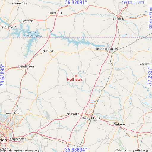
Hollister GPS coordinates[2]
36° 15' 21.528" North, 77° 56' 8.952" West
| Map corner | latitude | longitude |
|---|---|---|
| Upper-left | 36.82091°, | -78.63895° |
| Center: | 36.25598°, | -77.93582° |
| Lower-right: | 35.68694°, | -77.2327° |
| Map W x H: | 126.1×126.1 km | = 78.4×78.4mi |
| max Lat: | 71.29058° ⇑69.1% North |
| Hollister: | 36.25598° |
| min Lat: | ⇓30.9% South 19.06759° |
| min Long | Hollister | max Long |
| -171.73463° | -77.93582° | -66.98998° |
| W 77.9%⇐ | ⇒22.1% E |
Elevation
Elevation of Hollister is 79 m = 259 ft, and this is 215.8 m = 708 ft below average elevation for this country.
| Max E: |
3189 m = 10463 ft | 73.7% |
| Avg. | 294.8 m = 967 ft | |
| Hollister | 79 m = 259 ft | |
Min E: |
-60 m = -197 ft | 26.3% |
See also: United States elevation on elevation.city.
Geographical zone
Hollister is located in North temperate zone (between Tropic of Cancer and the Arctic Circle). Distance of this Northern Tropic circle is 1425.4 km =885.7 mi to South.| Distance of | km | miles | from Hollister |
|---|---|---|---|
| North Pole | 5975.8 | 3713.2 | to North |
| Arctic Circle | 3369.9 | 2094 | to North |
| Tropic Cancer | 1425.4 | 885.7 | to South |
| Equator | 4031.3 | 2504.9 | to South |


Nearby cities:
15 places around Hollister: (largest is in red/bold)
• Battleboro
28.5 km =17.7 mi,  143°
143°
• Dortches
28.1 km =17.5 mi,  165°
165°
• Enfield
25.5 km =15.8 mi,  109°
109°
• Halifax
32.1 km =19.9 mi,  75°
75°
• Littleton
20 km =12.4 mi,  6°
6°
• Louisburg
37.1 km =23.1 mi,  241°
241°
• Nashville
31.4 km =19.5 mi,  184°
184°
• Norlina
31.6 km =19.6 mi,  311°
311°
• Red Oak
24.3 km =15.1 mi, 173°
• Roanoke Rapids
34 km =21.1 mi,  47°
47°
• South Rosemary
30.5 km =19 mi,  44°
44°
• South Weldon
34.7 km =21.6 mi,  59°
59°
• Warrenton
25.2 km =15.7 mi, 308°
• Weldon
35.9 km =22.3 mi, 58°
• Whitakers
26.1 km =16.2 mi,  129°
129°
Sources, notices
• [Note1] Compared only with cities in United States existing in our database
• [Src1] Map data: © OpenStreetMap contributors (CC-BY-SA)
• [Src2] Other city data from geonames.org with taken over terms of usage.
• [Src3] Geographical zone / Annual Mean Temperature by Robert A. Rohde @ Wikipedia
