Bethel geodata
Bethel (North Carolina) is a populated place; located in United States in America/New_York (GMT-4) time zone. With population of 1,620 people, there are 13223 cities with bigger population in this country. Compared to other cities in United States, 71.3% of cities are located further ↑North; 79.3% of cities are located further ←West and 86.2% of cities have higher elevation than Bethel. Note1
Administrative division(s):
- Level 1: North Carolina
- Level 2: Pitt County
- Level 3: Township of Bethel


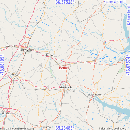
Bethel GPS coordinates[2]
35° 48' 25.56" North, 77° 22' 43.896" West
| Map corner | latitude | longitude |
|---|---|---|
| Upper-left | 36.37528°, | -78.08199° |
| Center: | 35.8071°, | -77.37886° |
| Lower-right: | 35.23483°, | -76.67574° |
| Map W x H: | 126.8×126.8 km | = 78.8×78.8mi |
| max Lat: | 71.29058° ⇑71.3% North |
| Bethel: | 35.8071° |
| min Lat: | ⇓28.7% South 19.06759° |
| min Long | Bethel | max Long |
| -171.73463° | -77.37886° | -66.98998° |
| W 79.3%⇐ | ⇒20.7% E |
Elevation
Elevation of Bethel is 25 m = 82 ft, and this is 269.8 m = 885 ft below average elevation for this country.
| Max E: |
3189 m = 10463 ft | 86.2% |
| Avg. | 294.8 m = 967 ft | |
| Bethel | 25 m = 82 ft | |
Min E: |
-60 m = -197 ft | 13.8% |
See also: United States elevation on elevation.city.
Geographical zone
Bethel is located in North temperate zone (between Tropic of Cancer and the Arctic Circle). Distance of this Northern Tropic circle is 1375.5 km =854.7 mi to South.| Distance of | km | miles | from Bethel |
|---|---|---|---|
| North Pole | 6025.7 | 3744.2 | to North |
| Arctic Circle | 3419.8 | 2125 | to North |
| Tropic Cancer | 1375.5 | 854.7 | to South |
| Equator | 3981.4 | 2473.9 | to South |


Nearby cities:
15 places around Bethel: (largest is in red/bold)
• Ayden
37.3 km =23.2 mi,  185°
185°
• Farmville
30 km =18.6 mi,  218°
218°
• Greenville
21.6 km =13.4 mi,  177°
177°
• Lewiston Woodville
39.6 km =24.6 mi,  27°
27°
• Maury
40.7 km =25.3 mi,  207°
207°
• Pinetops
23.4 km =14.5 mi,  264°
264°
• Princeville
16.6 km =10.3 mi,  303°
303°
• Robersonville
11.9 km =7.4 mi,  80°
80°
• Rocky Mount
39.9 km =24.8 mi,  291°
291°
• Scotland Neck
36.1 km =22.4 mi,  354°
354°
• Sharpsburg
41.1 km =25.5 mi,  279°
279°
• Tarboro
17.3 km =10.7 mi,  305°
305°
• Williamston
29.6 km =18.4 mi, 79°
• Windsor
28.3 km =17.6 mi, 176°
• Winterville
31 km =19.3 mi, 183°
Sources, notices
• [Note1] Compared only with cities in United States existing in our database
• [Src1] Map data: © OpenStreetMap contributors (CC-BY-SA)
• [Src2] Other city data from geonames.org with taken over terms of usage.
• [Src3] Geographical zone / Annual Mean Temperature by Robert A. Rohde @ Wikipedia
