Windsor geodata
Windsor (North Carolina) is a populated place; located in United States in America/New_York (GMT-4) time zone. With population of 2,192 people, there are 11366 cities with bigger population in this country. Compared to other cities in United States, 72.4% of cities are located further ↑North; 79.4% of cities are located further ←West and 87.8% of cities have higher elevation than Windsor. Note1
Administrative division(s):
- Level 1: North Carolina
- Level 2: Pitt County
- Level 3: Township of Winterville


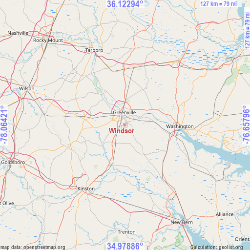
Windsor GPS coordinates[2]
35° 33' 10.584" North, 77° 21' 39.888" West
| Map corner | latitude | longitude |
|---|---|---|
| Upper-left | 36.12294°, | -78.06421° |
| Center: | 35.55294°, | -77.36108° |
| Lower-right: | 34.97886°, | -76.65796° |
| Map W x H: | 127.2×127.2 km | = 79×79mi |
| max Lat: | 71.29058° ⇑72.4% North |
| Windsor: | 35.55294° |
| min Lat: | ⇓27.6% South 19.06759° |
| min Long | Windsor | max Long |
| -171.73463° | -77.36108° | -66.98998° |
| W 79.4%⇐ | ⇒20.6% E |
Elevation
Elevation of Windsor is 21 m = 69 ft, and this is 273.8 m = 898 ft below average elevation for this country.
| Max E: |
3189 m = 10463 ft | 87.8% |
| Avg. | 294.8 m = 967 ft | |
| Windsor | 21 m = 69 ft | |
Min E: |
-60 m = -197 ft | 12.2% |
See also: United States elevation on elevation.city.
Geographical zone
Windsor is located in North temperate zone (between Tropic of Cancer and the Arctic Circle). Distance of this Northern Tropic circle is 1347.2 km =837.1 mi to South.| Distance of | km | miles | from Windsor |
|---|---|---|---|
| North Pole | 6053.9 | 3761.7 | to North |
| Arctic Circle | 3448.1 | 2142.5 | to North |
| Tropic Cancer | 1347.2 | 837.1 | to South |
| Equator | 3953.1 | 2456.3 | to South |


Nearby cities:
15 places around Windsor: (largest is in red/bold)
• Ayden
10.2 km =6.3 mi,  208°
208°
• Bethel
28.3 km =17.6 mi,  356°
356°
• Chocowinity
24 km =14.9 mi,  100°
100°
• Farmville
20.8 km =12.9 mi,  283°
283°
• Greenville
6.7 km =4.2 mi, 355°
• Grifton
21.2 km =13.2 mi,  199°
199°
• Kinston
38 km =23.6 mi, 211°
• Maury
21.8 km =13.5 mi,  248°
248°
• Pinetops
36.2 km =22.5 mi,  316°
316°
• River Road
33.9 km =21.1 mi, 98°
• Robersonville
31.9 km =19.8 mi,  18°
18°
• Snow Hill
31.1 km =19.3 mi, 248°
• Vanceboro
33 km =20.5 mi,  145°
145°
• Washington
28 km =17.4 mi,  91°
91°
• Winterville
4.5 km =2.8 mi,  233°
233°
Sources, notices
• [Note1] Compared only with cities in United States existing in our database
• [Src1] Map data: © OpenStreetMap contributors (CC-BY-SA)
• [Src2] Other city data from geonames.org with taken over terms of usage.
• [Src3] Geographical zone / Annual Mean Temperature by Robert A. Rohde @ Wikipedia
