Buies Creek geodata
Buies Creek (North Carolina) is a populated place; located in United States in America/New_York (GMT-4) time zone. With population of 2,942 people, there are 9733 cities with bigger population in this country. Compared to other cities in United States, 73.1% of cities are located further ↑North; 76.5% of cities are located further ←West and 75.5% of cities have higher elevation than Buies Creek. Note1
Administrative division(s):
- Level 1: North Carolina
- Level 2: Harnett County
- Level 3: Township of Neills Creek


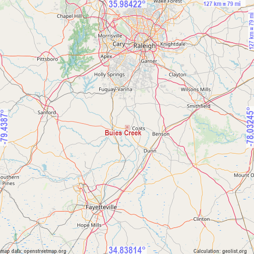
Buies Creek GPS coordinates[2]
35° 24' 47.592" North, 78° 44' 8.052" West
| Map corner | latitude | longitude |
|---|---|---|
| Upper-left | 35.98422°, | -79.4387° |
| Center: | 35.41322°, | -78.73557° |
| Lower-right: | 34.83814°, | -78.03245° |
| Map W x H: | 127.4×127.4 km | = 79.2×79.2mi |
| max Lat: | 71.29058° ⇑73.1% North |
| Buies Creek: | 35.41322° |
| min Lat: | ⇓26.9% South 19.06759° |
| min Long | Buies Creek | max Long |
| -171.73463° | -78.73557° | -66.98998° |
| W 76.5%⇐ | ⇒23.5% E |
Elevation
Elevation of Buies Creek is 69 m = 226 ft, and this is 225.8 m = 741 ft below average elevation for this country.
| Max E: |
3189 m = 10463 ft | 75.5% |
| Avg. | 294.8 m = 967 ft | |
| Buies Creek | 69 m = 226 ft | |
Min E: |
-60 m = -197 ft | 24.5% |
See also: United States elevation on elevation.city.
Geographical zone
Buies Creek is located in North temperate zone (between Tropic of Cancer and the Arctic Circle). Distance of this Northern Tropic circle is 1331.7 km =827.5 mi to South.| Distance of | km | miles | from Buies Creek |
|---|---|---|---|
| North Pole | 6069.5 | 3771.4 | to North |
| Arctic Circle | 3463.6 | 2152.2 | to North |
| Tropic Cancer | 1331.7 | 827.5 | to South |
| Equator | 3937.6 | 2446.7 | to South |


Nearby cities:
15 places around Buies Creek: (largest is in red/bold)
• Angier
10.4 km =6.5 mi,  358°
358°
• Benson
17.3 km =10.7 mi,  101°
101°
• Broadway
29.2 km =18.1 mi,  279°
279°
• Bunnlevel
12.2 km =7.6 mi,  199°
199°
• Coats
5.8 km =3.6 mi, 95°
• Dunn
16.5 km =10.3 mi,  135°
135°
• Erwin
11 km =6.8 mi,  150°
150°
• Four Oaks
28.2 km =17.5 mi,  82°
82°
• Fuquay-Varina
19.9 km =12.4 mi,  342°
342°
• Holly Springs
27.9 km =17.3 mi, 341°
• Lillington
7.4 km =4.6 mi,  258°
258°
• Mamers
17.9 km =11.1 mi,  271°
271°
• Plain View
24.6 km =15.3 mi, 138°
• Wade
27.8 km =17.3 mi,  180°
180°
• Walkertown
15.8 km =9.8 mi,  206°
206°
Sources, notices
• [Note1] Compared only with cities in United States existing in our database
• [Src1] Map data: © OpenStreetMap contributors (CC-BY-SA)
• [Src2] Other city data from geonames.org with taken over terms of usage.
• [Src3] Geographical zone / Annual Mean Temperature by Robert A. Rohde @ Wikipedia
