Holly Springs geodata
Holly Springs (North Carolina) is a populated place; located in United States in America/New_York (GMT-4) time zone. With population of 31,377 people, there are 1584 cities with bigger population in this country. Compared to other cities in United States, 72% of cities are located further ↑North; 76.2% of cities are located further ←West and 63.1% of cities have higher elevation than Holly Springs. Note1
Administrative division(s):
- Level 1: North Carolina
- Level 2: Wake County
- Level 3: Township of Holly Springs


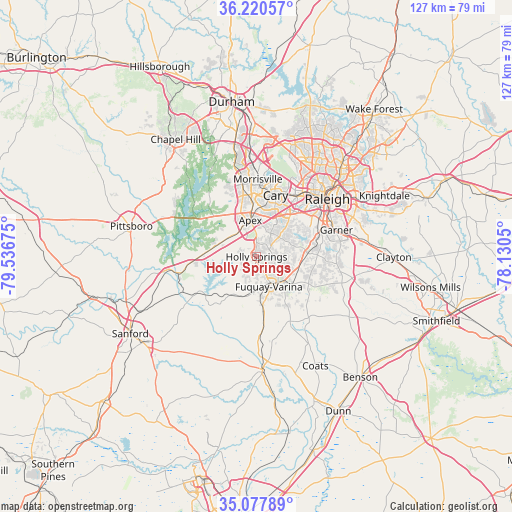
Holly Springs GPS coordinates[2]
35° 39' 4.572" North, 78° 50' 1.032" West
| Map corner | latitude | longitude |
|---|---|---|
| Upper-left | 36.22057°, | -79.53675° |
| Center: | 35.65127°, | -78.83362° |
| Lower-right: | 35.07789°, | -78.1305° |
| Map W x H: | 127.1×127.1 km | = 79×79mi |
| max Lat: | 71.29058° ⇑72% North |
| Holly Springs: | 35.65127° |
| min Lat: | ⇓28% South 19.06759° |
| min Long | Holly Springs | max Long |
| -171.73463° | -78.83362° | -66.98998° |
| W 76.2%⇐ | ⇒23.8% E |
Elevation
Elevation of Holly Springs is 138 m = 453 ft, and this is 156.8 m = 514 ft below average elevation for this country.
| Max E: |
3189 m = 10463 ft | 63.1% |
| Avg. | 294.8 m = 967 ft | |
| Holly Springs | 138 m = 453 ft | |
Min E: |
-60 m = -197 ft | 36.9% |
See also: United States elevation on elevation.city.
Geographical zone
Holly Springs is located in North temperate zone (between Tropic of Cancer and the Arctic Circle). Distance of this Northern Tropic circle is 1358.1 km =843.9 mi to South.| Distance of | km | miles | from Holly Springs |
|---|---|---|---|
| North Pole | 6043 | 3754.9 | to North |
| Arctic Circle | 3437.1 | 2135.7 | to North |
| Tropic Cancer | 1358.1 | 843.9 | to South |
| Equator | 3964 | 2463.1 | to South |


Nearby cities:
15 places around Holly Springs: (largest is in red/bold)
• Angier
18.2 km =11.3 mi,  151°
151°
• Apex
9.2 km =5.7 mi,  350°
350°
• Buies Creek
27.9 km =17.3 mi,  161°
161°
• Cary
16.3 km =10.1 mi,  16°
16°
• Fearrington
27.7 km =17.2 mi,  308°
308°
• Fuquay-Varina
8 km =5 mi, 157°
• Garner
20.9 km =13 mi,  71°
71°
• Green Level
15.9 km =9.9 mi,  336°
336°
• Lillington
28.1 km =17.5 mi,  176°
176°
• Mamers
27.6 km =17.1 mi,  199°
199°
• Moncure
22.3 km =13.9 mi,  261°
261°
• Morrisville
19.2 km =11.9 mi,  2°
2°
• Raleigh
22.1 km =13.7 mi,  52°
52°
• Scotts Mill
9.5 km =5.9 mi,  331°
331°
• West Raleigh
21.5 km =13.4 mi, 45°
Sources, notices
• [Note1] Compared only with cities in United States existing in our database
• [Src1] Map data: © OpenStreetMap contributors (CC-BY-SA)
• [Src2] Other city data from geonames.org with taken over terms of usage.
• [Src3] Geographical zone / Annual Mean Temperature by Robert A. Rohde @ Wikipedia
