Burlington geodata
Burlington (North Carolina) is a populated place; located in United States in America/New_York (GMT-4) time zone. With population of 52,472 people, there are 895 cities with bigger population in this country. Compared to other cities in United States, 70% of cities are located further ↑North; 75% of cities are located further ←West and 50.3% of cities have higher elevation than Burlington. Note1


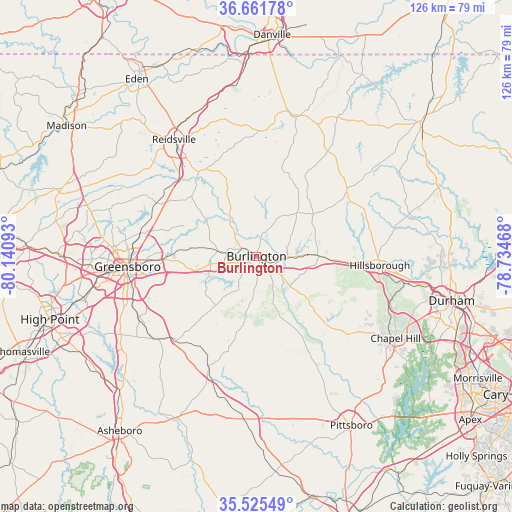
Burlington GPS coordinates[2]
36° 5' 44.484" North, 79° 26' 16.08" West
| Map corner | latitude | longitude |
|---|---|---|
| Upper-left | 36.66178°, | -80.14093° |
| Center: | 36.09569°, | -79.4378° |
| Lower-right: | 35.52549°, | -78.73468° |
| Map W x H: | 126.3×126.3 km | = 78.5×78.5mi |
| max Lat: | 71.29058° ⇑70% North |
| Burlington: | 36.09569° |
| min Lat: | ⇓30% South 19.06759° |
| min Long | Burlington | max Long |
| -171.73463° | -79.4378° | -66.98998° |
| W 75%⇐ | ⇒25% E |
Elevation
Elevation of Burlington is 197 m = 646 ft, and this is 97.8 m = 321 ft below average elevation for this country.
| Max E: |
3189 m = 10463 ft | 50.3% |
| Avg. | 294.8 m = 967 ft | |
| Burlington | 197 m = 646 ft | |
Min E: |
-60 m = -197 ft | 49.7% |
See also: Burlington elevation on elevation.city.
Geographical zone
Burlington is located in North temperate zone (between Tropic of Cancer and the Arctic Circle). Distance of this Northern Tropic circle is 1407.5 km =874.6 mi to South.| Distance of | km | miles | from Burlington |
|---|---|---|---|
| North Pole | 5993.6 | 3724.2 | to North |
| Arctic Circle | 3387.7 | 2105 | to North |
| Tropic Cancer | 1407.5 | 874.6 | to South |
| Equator | 4013.5 | 2493.9 | to South |


Nearby cities:
15 places around Burlington: (largest is in red/bold)
• Alamance
8 km =5 mi,  212°
212°
• Elon
6.2 km =3.9 mi,  277°
277°
• Gibsonville
9.4 km =5.8 mi, 276°
• Glen Raven
4 km =2.5 mi,  299°
299°
• Graham
4.5 km =2.8 mi,  131°
131°
• Green Level
8.9 km =5.5 mi,  71°
71°
• Haw River
6.6 km =4.1 mi,  94°
94°
• McLeansville
19.9 km =12.4 mi,  273°
273°
• Mebane
15.3 km =9.5 mi, 89°
• Ossipee
10.7 km =6.6 mi,  322°
322°
• Saxapahaw
19.5 km =12.1 mi,  147°
147°
• Sedalia
16.7 km =10.4 mi,  259°
259°
• Swepsonville
10.8 km =6.7 mi,  140°
140°
• Whitsett
11.7 km =7.3 mi, 256°
• Woodlawn
12.9 km =8 mi,  82°
82°
Sources, notices
• [Note1] Compared only with cities in United States existing in our database
• [Src1] Map data: © OpenStreetMap contributors (CC-BY-SA)
• [Src2] Other city data from geonames.org with taken over terms of usage.
• [Src3] Geographical zone / Annual Mean Temperature by Robert A. Rohde @ Wikipedia
