Green Level geodata
Green Level (North Carolina) is a populated place; located in United States in America/New_York (GMT-4) time zone. With population of 2,160 people, there are 11439 cities with bigger population in this country. Compared to other cities in United States, 69.8% of cities are located further ↑North; 75.1% of cities are located further ←West and 53.3% of cities have higher elevation than Green Level. Note1


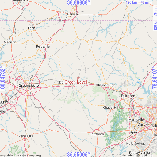
Green Level GPS coordinates[2]
36° 7' 15.492" North, 79° 20' 39.084" West
| Map corner | latitude | longitude |
|---|---|---|
| Upper-left | 36.68688°, | -80.04732° |
| Center: | 36.12097°, | -79.34419° |
| Lower-right: | 35.55095°, | -78.64107° |
| Map W x H: | 126.3×126.3 km | = 78.5×78.5mi |
| max Lat: | 71.29058° ⇑69.8% North |
| Green Level: | 36.12097° |
| min Lat: | ⇓30.2% South 19.06759° |
| min Long | Green Level | max Long |
| -171.73463° | -79.34419° | -66.98998° |
| W 75.1%⇐ | ⇒24.9% E |
Elevation
Elevation of Green Level is 186 m = 610 ft, and this is 108.8 m = 357 ft below average elevation for this country.
| Max E: |
3189 m = 10463 ft | 53.3% |
| Avg. | 294.8 m = 967 ft | |
| Green Level | 186 m = 610 ft | |
Min E: |
-60 m = -197 ft | 46.7% |
See also: United States elevation on elevation.city.
Geographical zone
Green Level is located in North temperate zone (between Tropic of Cancer and the Arctic Circle). Distance of this Northern Tropic circle is 1410.4 km =876.4 mi to South.| Distance of | km | miles | from Green Level |
|---|---|---|---|
| North Pole | 5990.8 | 3722.5 | to North |
| Arctic Circle | 3384.9 | 2103.3 | to North |
| Tropic Cancer | 1410.4 | 876.4 | to South |
| Equator | 4016.3 | 2495.6 | to South |


Nearby cities:
15 places around Green Level: (largest is in red/bold)
• Alamance
15.9 km =9.9 mi,  233°
233°
• Burlington
8.9 km =5.5 mi,  251°
251°
• Efland
16.3 km =10.1 mi,  105°
105°
• Elon
14.7 km =9.1 mi,  262°
262°
• Gibsonville
17.9 km =11.1 mi, 264°
• Glen Raven
11.9 km =7.4 mi,  265°
265°
• Graham
7.7 km =4.8 mi,  221°
221°
• Haw River
3.7 km =2.3 mi,  208°
208°
• Hillsborough
22.5 km =14 mi,  102°
102°
• Mebane
7.5 km =4.7 mi, 111°
• Ossipee
16 km =9.9 mi,  290°
290°
• Saxapahaw
19.4 km =12.1 mi,  174°
174°
• Swepsonville
11.2 km =7 mi,  187°
187°
• Whitsett
20.5 km =12.7 mi, 254°
• Woodlawn
4.6 km =2.9 mi, 105°
Sources, notices
• [Note1] Compared only with cities in United States existing in our database
• [Src1] Map data: © OpenStreetMap contributors (CC-BY-SA)
• [Src2] Other city data from geonames.org with taken over terms of usage.
• [Src3] Geographical zone / Annual Mean Temperature by Robert A. Rohde @ Wikipedia
