Carolina Shores geodata
Carolina Shores (North Carolina) is a populated place; located in United States in America/New_York (GMT-4) time zone. With population of 3,767 people, there are 8501 cities with bigger population in this country. Compared to other cities in United States, 80.9% of cities are located further ↑North; 76.8% of cities are located further ←West and 99.4% of cities have higher elevation than Carolina Shores. Note1
Administrative division(s):
- Level 1: North Carolina
- Level 2: Brunswick County
- Level 3: Township of Shallotte


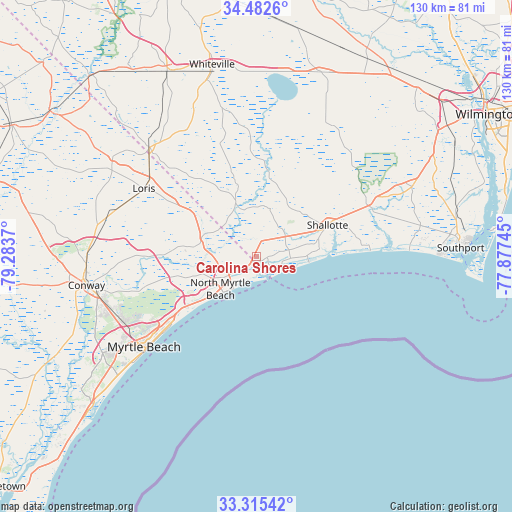
Carolina Shores GPS coordinates[2]
33° 54' 3.636" North, 78° 34' 50.052" West
| Map corner | latitude | longitude |
|---|---|---|
| Upper-left | 34.4826°, | -79.2837° |
| Center: | 33.90101°, | -78.58057° |
| Lower-right: | 33.31542°, | -77.87745° |
| Map W x H: | 129.8×129.8 km | = 80.7×80.7mi |
| max Lat: | 71.29058° ⇑80.9% North |
| Carolina Shores: | 33.90101° |
| min Lat: | ⇓19.1% South 19.06759° |
| min Long | Carolina Shores | max Long |
| -171.73463° | -78.58057° | -66.98998° |
| W 76.8%⇐ | ⇒23.2% E |
Elevation
Elevation of Carolina Shores is 2 m = 7 ft, and this is 292.8 m = 961 ft below average elevation for this country.
| Max E: |
3189 m = 10463 ft | 99.4% |
| Avg. | 294.8 m = 967 ft | |
| Carolina Shores | 2 m = 7 ft | |
Min E: |
-60 m = -197 ft | 0.6% |
See also: United States elevation on elevation.city.
Geographical zone
Carolina Shores is located in North temperate zone (between Tropic of Cancer and the Arctic Circle). Distance of this Northern Tropic circle is 1163.5 km =723 mi to South.| Distance of | km | miles | from Carolina Shores |
|---|---|---|---|
| North Pole | 6237.6 | 3875.9 | to North |
| Arctic Circle | 3631.7 | 2256.6 | to North |
| Tropic Cancer | 1163.5 | 723 | to South |
| Equator | 3769.4 | 2342.2 | to South |


Nearby cities:
15 places around Carolina Shores: (largest is in red/bold)
• Briarcliffe Acres
19.8 km =12.3 mi,  229°
229°
• Calabash
1.6 km =1 mi,  135°
135°
• Forestbrook
40.1 km =24.9 mi,  240°
240°
• Holden Beach
25.6 km =15.9 mi,  86°
86°
• Little River
4.4 km =2.7 mi, 225°
• Loris
33.4 km =20.8 mi,  301°
301°
• Myrtle Beach
36.8 km =22.9 mi, 230°
• North Myrtle Beach
13.2 km =8.2 mi,  224°
224°
• Oak Island
38.7 km =24 mi, 87°
• Ocean Isle Beach
14.2 km =8.8 mi, 92°
• Red Hill
41.4 km =25.7 mi,  257°
257°
• Shallotte
19.7 km =12.2 mi,  65°
65°
• Sunset Beach
6.7 km =4.2 mi,  109°
109°
• Tabor City
38.8 km =24.1 mi,  315°
315°
• Varnamtown
30.9 km =19.2 mi,  82°
82°
Sources, notices
• [Note1] Compared only with cities in United States existing in our database
• [Src1] Map data: © OpenStreetMap contributors (CC-BY-SA)
• [Src2] Other city data from geonames.org with taken over terms of usage.
• [Src3] Geographical zone / Annual Mean Temperature by Robert A. Rohde @ Wikipedia
