Shallotte geodata
Shallotte (North Carolina) is a populated place; located in United States in America/New_York (GMT-4) time zone. With population of 3,991 people, there are 8229 cities with bigger population in this country. Compared to other cities in United States, 80.4% of cities are located further ↑North; 77.1% of cities are located further ←West and 99.7% of cities have higher elevation than Shallotte. Note1
Administrative division(s):
- Level 1: North Carolina
- Level 2: Brunswick County
- Level 3: Township of Lockwoods Folly


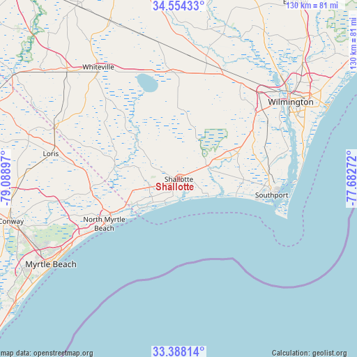
Shallotte GPS coordinates[2]
33° 58' 23.628" North, 78° 23' 9.024" West
| Map corner | latitude | longitude |
|---|---|---|
| Upper-left | 34.55433°, | -79.08897° |
| Center: | 33.97323°, | -78.38584° |
| Lower-right: | 33.38814°, | -77.68272° |
| Map W x H: | 129.7×129.7 km | = 80.6×80.6mi |
| max Lat: | 71.29058° ⇑80.4% North |
| Shallotte: | 33.97323° |
| min Lat: | ⇓19.6% South 19.06759° |
| min Long | Shallotte | max Long |
| -171.73463° | -78.38584° | -66.98998° |
| W 77.1%⇐ | ⇒22.9% E |
Elevation
Elevation of Shallotte is 0 m = 0 ft, and this is 294.8 m = 967 ft below average elevation for this country.
| Max E: |
3189 m = 10463 ft | 99.7% |
| Avg. | 294.8 m = 967 ft | |
| Shallotte | 0 m = 0 ft | |
Min E: |
-60 m = -197 ft | 0.3% |
See also: United States elevation on elevation.city.
Geographical zone
Shallotte is located in North temperate zone (between Tropic of Cancer and the Arctic Circle). Distance of this Northern Tropic circle is 1171.6 km =728 mi to South.| Distance of | km | miles | from Shallotte |
|---|---|---|---|
| North Pole | 6229.6 | 3870.9 | to North |
| Arctic Circle | 3623.7 | 2251.7 | to North |
| Tropic Cancer | 1171.6 | 728 | to South |
| Equator | 3777.5 | 2347.2 | to South |


Nearby cities:
15 places around Shallotte: (largest is in red/bold)
• Boiling Spring Lakes
30.1 km =18.7 mi,  77°
77°
• Bolivia
24.3 km =15.1 mi,  64°
64°
• Calabash
19.2 km =11.9 mi,  241°
241°
• Carolina Shores
19.7 km =12.2 mi,  245°
245°
• Holden Beach
10.1 km =6.3 mi,  131°
131°
• Little River
23.8 km =14.8 mi, 242°
• Long Beach
25.7 km =16 mi,  105°
105°
• North Myrtle Beach
32.3 km =20.1 mi, 237°
• Oak Island
21.7 km =13.5 mi, 106°
• Ocean Isle Beach
9.5 km =5.9 mi,  203°
203°
• Saint James
25.3 km =15.7 mi,  101°
101°
• Southport
34.2 km =21.3 mi, 99°
• Sunset Beach
15.5 km =9.6 mi,  228°
228°
• Varnamtown
13.3 km =8.3 mi, 108°
• Yaupon Beach
29.4 km =18.3 mi, 104°
Sources, notices
• [Note1] Compared only with cities in United States existing in our database
• [Src1] Map data: © OpenStreetMap contributors (CC-BY-SA)
• [Src2] Other city data from geonames.org with taken over terms of usage.
• [Src3] Geographical zone / Annual Mean Temperature by Robert A. Rohde @ Wikipedia
