Germanton geodata
Germanton (North Carolina) is a populated place; located in United States in America/New_York (GMT-4) time zone. With population of 827 people, there are 17545 cities with bigger population in this country. Compared to other cities in United States, 69.1% of cities are located further ↑North; 72.1% of cities are located further ←West and 53% of cities have lower elevation than Germanton. Note1
Administrative division(s):
- Level 1: North Carolina
- Level 2: Stokes County
- Level 3: Township of Meadows


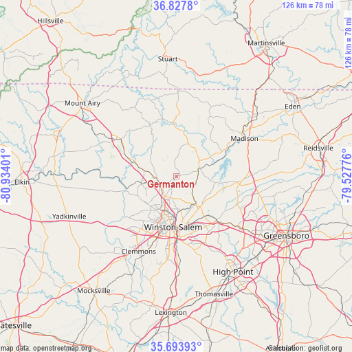
Germanton GPS coordinates[2]
36° 15' 46.512" North, 80° 13' 51.168" West
| Map corner | latitude | longitude |
|---|---|---|
| Upper-left | 36.8278°, | -80.93401° |
| Center: | 36.26292°, | -80.23088° |
| Lower-right: | 35.69393°, | -79.52776° |
| Map W x H: | 126.1×126.1 km | = 78.4×78.4mi |
| max Lat: | 71.29058° ⇑69.1% North |
| Germanton: | 36.26292° |
| min Lat: | ⇓30.9% South 19.06759° |
| min Long | Germanton | max Long |
| -171.73463° | -80.23088° | -66.98998° |
| W 72.1%⇐ | ⇒27.9% E |
Elevation
Elevation of Germanton is 210 m = 689 ft, and this is 84.8 m = 278 ft below average elevation for this country.
| Max E: |
3189 m = 10463 ft | 47% |
| Avg. | 294.8 m = 967 ft | |
| Germanton | 210 m = 689 ft | |
Min E: |
-60 m = -197 ft | 53% |
See also: United States elevation on elevation.city.
Geographical zone
Germanton is located in North temperate zone (between Tropic of Cancer and the Arctic Circle). Distance of this Northern Tropic circle is 1426.1 km =886.1 mi to South.| Distance of | km | miles | from Germanton |
|---|---|---|---|
| North Pole | 5975 | 3712.7 | to North |
| Arctic Circle | 3369.1 | 2093.5 | to North |
| Tropic Cancer | 1426.1 | 886.1 | to South |
| Equator | 4032.1 | 2505.4 | to South |


Nearby cities:
15 places around Germanton: (largest is in red/bold)
• Danbury
16.4 km =10.2 mi,  7°
7°
• East Bend
25.8 km =16 mi,  258°
258°
• Kernersville
21.3 km =13.2 mi,  138°
138°
• King
11.7 km =7.3 mi,  279°
279°
• Lewisville
25 km =15.5 mi,  222°
222°
• Madison
27.9 km =17.3 mi,  60°
60°
• Oak Ridge
23.9 km =14.9 mi,  114°
114°
• Pilot Mountain
25.4 km =15.8 mi,  302°
302°
• Pinnacle
19.6 km =12.2 mi,  292°
292°
• Rural Hall
6.1 km =3.8 mi,  245°
245°
• Stokesdale
22.7 km =14.1 mi,  97°
97°
• Tobaccoville
12.9 km =8 mi, 257°
• Walkertown
12 km =7.5 mi, 144°
• Walnut Cove
8.8 km =5.5 mi,  65°
65°
• Winston-Salem
18.2 km =11.3 mi,  183°
183°
Sources, notices
• [Note1] Compared only with cities in United States existing in our database
• [Src1] Map data: © OpenStreetMap contributors (CC-BY-SA)
• [Src2] Other city data from geonames.org with taken over terms of usage.
• [Src3] Geographical zone / Annual Mean Temperature by Robert A. Rohde @ Wikipedia
