Gibson geodata
Gibson (North Carolina) is a populated place; located in United States in America/New_York (GMT-4) time zone. With population of 519 people, there are 20641 cities with bigger population in this country. Compared to other cities in United States, 76.5% of cities are located further ↑North; 74.6% of cities are located further ←West and 74% of cities have higher elevation than Gibson. Note1
Administrative division(s):
- Level 1: North Carolina
- Level 2: Scotland County
- Level 3: Township of Williamson


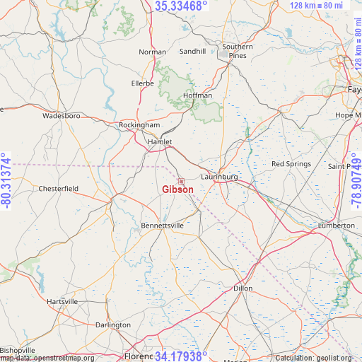
Gibson GPS coordinates[2]
34° 45' 32.58" North, 79° 36' 38.196" West
| Map corner | latitude | longitude |
|---|---|---|
| Upper-left | 35.33468°, | -80.31374° |
| Center: | 34.75905°, | -79.61061° |
| Lower-right: | 34.17938°, | -78.90749° |
| Map W x H: | 128.5×128.5 km | = 79.8×79.8mi |
| max Lat: | 71.29058° ⇑76.5% North |
| Gibson: | 34.75905° |
| min Lat: | ⇓23.5% South 19.06759° |
| min Long | Gibson | max Long |
| -171.73463° | -79.61061° | -66.98998° |
| W 74.6%⇐ | ⇒25.4% E |
Elevation
Elevation of Gibson is 77 m = 253 ft, and this is 217.8 m = 715 ft below average elevation for this country.
| Max E: |
3189 m = 10463 ft | 74% |
| Avg. | 294.8 m = 967 ft | |
| Gibson | 77 m = 253 ft | |
Min E: |
-60 m = -197 ft | 26% |
See also: United States elevation on elevation.city.
Geographical zone
Gibson is located in North temperate zone (between Tropic of Cancer and the Arctic Circle). Distance of this Northern Tropic circle is 1258.9 km =782.2 mi to South.| Distance of | km | miles | from Gibson |
|---|---|---|---|
| North Pole | 6142.2 | 3816.6 | to North |
| Arctic Circle | 3536.3 | 2197.4 | to North |
| Tropic Cancer | 1258.9 | 782.2 | to South |
| Equator | 3864.8 | 2401.5 | to South |


Nearby cities:
15 places around Gibson: (largest is in red/bold)
• Bennettsville
17.1 km =10.6 mi,  203°
203°
• Cheraw
25.8 km =16 mi,  254°
254°
• Clio
20.8 km =12.9 mi,  163°
163°
• Cordova
25.8 km =16 mi,  311°
311°
• Dobbins Heights
17.8 km =11.1 mi,  335°
335°
• East Rockingham
22.5 km =14 mi,  321°
321°
• Hamlet
15.9 km =9.9 mi,  331°
331°
• Hoffman
30.9 km =19.2 mi,  10°
10°
• Laurel Hill
8 km =5 mi,  45°
45°
• Laurinburg
13.6 km =8.5 mi,  82°
82°
• Maxton
24.1 km =15 mi,  96°
96°
• McColl
11.7 km =7.3 mi,  149°
149°
• Rockingham
25 km =15.5 mi, 323°
• Wagram
26.5 km =16.5 mi,  57°
57°
• Wallace
21.5 km =13.4 mi,  258°
258°
Sources, notices
• [Note1] Compared only with cities in United States existing in our database
• [Src1] Map data: © OpenStreetMap contributors (CC-BY-SA)
• [Src2] Other city data from geonames.org with taken over terms of usage.
• [Src3] Geographical zone / Annual Mean Temperature by Robert A. Rohde @ Wikipedia
