Cheraw geodata
Cheraw (South Carolina) is a populated place; located in United States in America/New_York (GMT-4) time zone. With population of 5,778 people, there are 6558 cities with bigger population in this country. Compared to other cities in United States, 76.9% of cities are located further ↑North; 73.8% of cities are located further ←West and 79.9% of cities have higher elevation than Cheraw. Note1


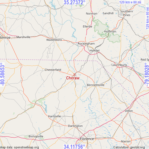
Cheraw GPS coordinates[2]
34° 41' 51.576" North, 79° 53' 0.24" West
| Map corner | latitude | longitude |
|---|---|---|
| Upper-left | 35.27372°, | -80.58653° |
| Center: | 34.69766°, | -79.8834° |
| Lower-right: | 34.11756°, | -79.18028° |
| Map W x H: | 128.6×128.6 km | = 79.9×79.9mi |
| max Lat: | 71.29058° ⇑76.9% North |
| Cheraw: | 34.69766° |
| min Lat: | ⇓23.1% South 19.06759° |
| min Long | Cheraw | max Long |
| -171.73463° | -79.8834° | -66.98998° |
| W 73.8%⇐ | ⇒26.2% E |
Elevation
Elevation of Cheraw is 47 m = 154 ft, and this is 247.8 m = 813 ft below average elevation for this country.
| Max E: |
3189 m = 10463 ft | 79.9% |
| Avg. | 294.8 m = 967 ft | |
| Cheraw | 47 m = 154 ft | |
Min E: |
-60 m = -197 ft | 20.1% |
See also: United States elevation on elevation.city.
Geographical zone
Cheraw is located in North temperate zone (between Tropic of Cancer and the Arctic Circle). Distance of this Northern Tropic circle is 1252.1 km =778 mi to South.| Distance of | km | miles | from Cheraw |
|---|---|---|---|
| North Pole | 6149 | 3820.8 | to North |
| Arctic Circle | 3543.2 | 2201.6 | to North |
| Tropic Cancer | 1252.1 | 778 | to South |
| Equator | 3858 | 2397.2 | to South |


Nearby cities:
15 places around Cheraw: (largest is in red/bold)
• Bennettsville
20.2 km =12.6 mi,  116°
116°
• Chesterfield
19.2 km =11.9 mi,  282°
282°
• Clio
33.5 km =20.8 mi,  113°
113°
• Cordova
24.6 km =15.3 mi,  13°
13°
• Dobbins Heights
28.9 km =18 mi,  37°
37°
• East Rockingham
26.9 km =16.7 mi,  24°
24°
• Gibson
25.8 km =16 mi,  74°
74°
• Hamlet
27.1 km =16.8 mi, 39°
• Laurel Hill
33.1 km =20.6 mi, 68°
• Lilesville
31.4 km =19.5 mi,  342°
342°
• McColl
31.1 km =19.3 mi,  95°
95°
• Rockingham
28.7 km =17.8 mi, 20°
• Society Hill
20.8 km =12.9 mi,  171°
171°
• Wadesboro
34.9 km =21.7 mi,  329°
329°
• Wallace
4.6 km =2.9 mi,  56°
56°
Sources, notices
• [Note1] Compared only with cities in United States existing in our database
• [Src1] Map data: © OpenStreetMap contributors (CC-BY-SA)
• [Src2] Other city data from geonames.org with taken over terms of usage.
• [Src3] Geographical zone / Annual Mean Temperature by Robert A. Rohde @ Wikipedia
