Hillsborough geodata
Hillsborough (North Carolina) is a seat of a second-order administrative division; located in United States in America/New_York (GMT-4) time zone. With population of 6,415 people, there are 6166 cities with bigger population in this country. Compared to other cities in United States, 70.1% of cities are located further ↑North; 75.5% of cities are located further ←West and 57.7% of cities have higher elevation than Hillsborough. Note1
Administrative division(s):
- Level 1: North Carolina
- Level 2: Orange County
- Level 3: Township of Hillsborough


Hillsborough GPS coordinates[2]
36° 4' 31.512" North, 79° 5' 59.028" West
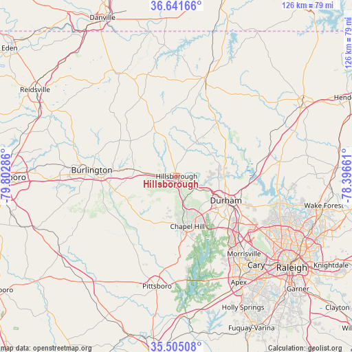
| Map corner | latitude | longitude |
|---|---|---|
| Upper-left | 36.64166°, | -79.80286° |
| Center: | 36.07542°, | -79.09973° |
| Lower-right: | 35.50508°, | -78.39661° |
| Map W x H: | 126.4×126.4 km | = 78.5×78.5mi |
| max Lat: | 71.29058° ⇑70.1% North |
| Hillsborough: | 36.07542° |
| min Lat: | ⇓29.9% South 19.06759° |
| min Long | Hillsborough | max Long |
| -171.73463° | -79.09973° | -66.98998° |
| W 75.5%⇐ | ⇒24.5% E |
Elevation
Elevation of Hillsborough is 167 m = 548 ft, and this is 127.8 m = 419 ft below average elevation for this country.
| Max E: |
3189 m = 10463 ft | 57.7% |
| Avg. | 294.8 m = 967 ft | |
| Hillsborough | 167 m = 548 ft | |
Min E: |
-60 m = -197 ft | 42.3% |
See also: United States elevation on elevation.city.
Geographical zone
Hillsborough is located in North temperate zone (between Tropic of Cancer and the Arctic Circle). Distance of this Northern Tropic circle is 1405.3 km =873.2 mi to South.| Distance of | km | miles | from Hillsborough |
|---|---|---|---|
| North Pole | 5995.9 | 3725.7 | to North |
| Arctic Circle | 3390 | 2106.4 | to North |
| Tropic Cancer | 1405.3 | 873.2 | to South |
| Equator | 4011.2 | 2492.4 | to South |


Nearby cities:
15 places around Hillsborough: (largest is in red/bold)
• Carrboro
18.5 km =11.5 mi,  173°
173°
• Chapel Hill
18.5 km =11.5 mi, 167°
• Durham
20.2 km =12.6 mi,  116°
116°
• Efland
6.3 km =3.9 mi,  275°
275°
• Fearrington
30 km =18.6 mi,  175°
175°
• Fearrington Village
30.2 km =18.8 mi, 178°
• Gorman
25.2 km =15.7 mi,  99°
99°
• Graham
27 km =16.8 mi,  268°
268°
• Green Level
22.5 km =14 mi, 282°
• Haw River
23.8 km =14.8 mi, 274°
• Mebane
15.2 km =9.4 mi, 278°
• Rougemont
22.3 km =13.9 mi,  44°
44°
• Saxapahaw
24.5 km =15.2 mi,  234°
234°
• Swepsonville
24.3 km =15.1 mi,  255°
255°
• Woodlawn
18 km =11.2 mi, 282°
Sources, notices
• [Note1] Compared only with cities in United States existing in our database
• [Src1] Map data: © OpenStreetMap contributors (CC-BY-SA)
• [Src2] Other city data from geonames.org with taken over terms of usage.
• [Src3] Geographical zone / Annual Mean Temperature by Robert A. Rohde @ Wikipedia
