Hemby Bridge geodata
Hemby Bridge (North Carolina) is a populated place; located in United States in America/New_York (GMT-4) time zone. With population of 1,676 people, there are 12993 cities with bigger population in this country. Compared to other cities in United States, 74.8% of cities are located further ↑North; 70.5% of cities are located further ←West and 51.4% of cities have higher elevation than Hemby Bridge. Note1
Administrative division(s):
- Level 1: North Carolina
- Level 2: Union County
- Level 3: Township of Vance


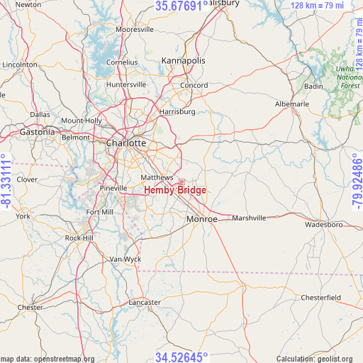
Hemby Bridge GPS coordinates[2]
35° 6' 13.356" North, 80° 37' 40.728" West
| Map corner | latitude | longitude |
|---|---|---|
| Upper-left | 35.67691°, | -81.33111° |
| Center: | 35.10371°, | -80.62798° |
| Lower-right: | 34.52645°, | -79.92486° |
| Map W x H: | 127.9×127.9 km | = 79.5×79.5mi |
| max Lat: | 71.29058° ⇑74.8% North |
| Hemby Bridge: | 35.10371° |
| min Lat: | ⇓25.2% South 19.06759° |
| min Long | Hemby Bridge | max Long |
| -171.73463° | -80.62798° | -66.98998° |
| W 70.5%⇐ | ⇒29.5% E |
Elevation
Elevation of Hemby Bridge is 193 m = 633 ft, and this is 101.8 m = 334 ft below average elevation for this country.
| Max E: |
3189 m = 10463 ft | 51.4% |
| Avg. | 294.8 m = 967 ft | |
| Hemby Bridge | 193 m = 633 ft | |
Min E: |
-60 m = -197 ft | 48.6% |
See also: United States elevation on elevation.city.
Geographical zone
Hemby Bridge is located in North temperate zone (between Tropic of Cancer and the Arctic Circle). Distance of this Northern Tropic circle is 1297.2 km =806 mi to South.| Distance of | km | miles | from Hemby Bridge |
|---|---|---|---|
| North Pole | 6103.9 | 3792.8 | to North |
| Arctic Circle | 3498 | 2173.6 | to North |
| Tropic Cancer | 1297.2 | 806 | to South |
| Equator | 3903.2 | 2425.3 | to South |


Nearby cities:
15 places around Hemby Bridge: (largest is in red/bold)
• Fairview
9.1 km =5.7 mi,  64°
64°
• Indian Trail
4.8 km =3 mi,  231°
231°
• Lake Park
2 km =1.2 mi,  198°
198°
• Marvin
21.1 km =13.1 mi, 233°
• Matthews
8.8 km =5.5 mi,  279°
279°
• Midland
18 km =11.2 mi,  40°
40°
• Mineral Springs
18.8 km =11.7 mi,  191°
191°
• Mint Hill
8.6 km =5.3 mi,  348°
348°
• Monroe
15 km =9.3 mi,  151°
151°
• Stallings
5.5 km =3.4 mi,  254°
254°
• Unionville
11 km =6.8 mi,  99°
99°
• Waxhaw
22.5 km =14 mi,  207°
207°
• Weddington
15.1 km =9.4 mi, 233°
• Wesley Chapel
11.5 km =7.1 mi, 201°
• Wingate
21 km =13 mi,  129°
129°
Sources, notices
• [Note1] Compared only with cities in United States existing in our database
• [Src1] Map data: © OpenStreetMap contributors (CC-BY-SA)
• [Src2] Other city data from geonames.org with taken over terms of usage.
• [Src3] Geographical zone / Annual Mean Temperature by Robert A. Rohde @ Wikipedia
