Wesley Chapel geodata
Wesley Chapel (North Carolina) is a populated place; located in United States in America/New_York (GMT-4) time zone. With population of 8,355 people, there are 5106 cities with bigger population in this country. Compared to other cities in United States, 75.4% of cities are located further ↑North; 70.3% of cities are located further ←West and 53.3% of cities have higher elevation than Wesley Chapel. Note1
Administrative division(s):
- Level 1: North Carolina
- Level 2: Union County
- Level 3: Township of Sandy Ridge


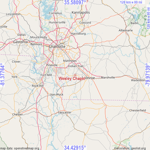
Wesley Chapel GPS coordinates[2]
35° 0' 25.524" North, 80° 40' 28.236" West
| Map corner | latitude | longitude |
|---|---|---|
| Upper-left | 35.58097°, | -81.37764° |
| Center: | 35.00709°, | -80.67451° |
| Lower-right: | 34.42915°, | -79.97139° |
| Map W x H: | 128.1×128.1 km | = 79.6×79.6mi |
| max Lat: | 71.29058° ⇑75.4% North |
| Wesley Chapel: | 35.00709° |
| min Lat: | ⇓24.6% South 19.06759° |
| min Long | Wesley Chapel | max Long |
| -171.73463° | -80.67451° | -66.98998° |
| W 70.3%⇐ | ⇒29.7% E |
Elevation
Elevation of Wesley Chapel is 186 m = 610 ft, and this is 108.8 m = 357 ft below average elevation for this country.
| Max E: |
3189 m = 10463 ft | 53.3% |
| Avg. | 294.8 m = 967 ft | |
| Wesley Chapel | 186 m = 610 ft | |
Min E: |
-60 m = -197 ft | 46.7% |
See also: United States elevation on elevation.city.
Geographical zone
Wesley Chapel is located in North temperate zone (between Tropic of Cancer and the Arctic Circle). Distance of this Northern Tropic circle is 1286.5 km =799.4 mi to South.| Distance of | km | miles | from Wesley Chapel |
|---|---|---|---|
| North Pole | 6114.6 | 3799.4 | to North |
| Arctic Circle | 3508.8 | 2180.3 | to North |
| Tropic Cancer | 1286.5 | 799.4 | to South |
| Equator | 3892.4 | 2418.6 | to South |


Nearby cities:
15 places around Wesley Chapel: (largest is in red/bold)
• Fairview
19.2 km =11.9 mi,  40°
40°
• Hemby Bridge
11.5 km =7.1 mi,  21°
21°
• Indian Trail
7.8 km =4.8 mi,  3°
3°
• Jaars
17.2 km =10.7 mi,  202°
202°
• Lake Park
9.5 km =5.9 mi, 22°
• Marvin
12.9 km =8 mi,  262°
262°
• Matthews
13 km =8.1 mi,  339°
339°
• Mineral Springs
7.7 km =4.8 mi,  176°
176°
• Mint Hill
19.3 km =12 mi,  7°
7°
• Monroe
11.6 km =7.2 mi,  101°
101°
• Stallings
9.4 km =5.8 mi,  353°
353°
• Unionville
17.5 km =10.9 mi,  59°
59°
• Waxhaw
11.1 km =6.9 mi,  214°
214°
• Weddington
8 km =5 mi,  282°
282°
• Wingate
20.7 km =12.9 mi, 97°
Sources, notices
• [Note1] Compared only with cities in United States existing in our database
• [Src1] Map data: © OpenStreetMap contributors (CC-BY-SA)
• [Src2] Other city data from geonames.org with taken over terms of usage.
• [Src3] Geographical zone / Annual Mean Temperature by Robert A. Rohde @ Wikipedia
