Jaars geodata
Jaars (North Carolina) is a populated place; located in United States in America/New_York (GMT-4) time zone. With population of 597 people, there are 19737 cities with bigger population in this country. Compared to other cities in United States, 76.1% of cities are located further ↑North; 70.1% of cities are located further ←West and 56% of cities have higher elevation than Jaars. Note1
Administrative division(s):
- Level 1: North Carolina
- Level 2: Union County
- Level 3: Township of Jackson


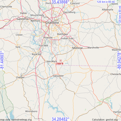
Jaars GPS coordinates[2]
34° 51' 49.536" North, 80° 44' 45.24" West
| Map corner | latitude | longitude |
|---|---|---|
| Upper-left | 35.43866°, | -81.44903° |
| Center: | 34.86376°, | -80.7459° |
| Lower-right: | 34.28482°, | -80.04278° |
| Map W x H: | 128.3×128.3 km | = 79.7×79.7mi |
| max Lat: | 71.29058° ⇑76.1% North |
| Jaars: | 34.86376° |
| min Lat: | ⇓23.9% South 19.06759° |
| min Long | Jaars | max Long |
| -171.73463° | -80.7459° | -66.98998° |
| W 70.1%⇐ | ⇒29.9% E |
Elevation
Elevation of Jaars is 176 m = 577 ft, and this is 118.8 m = 390 ft below average elevation for this country.
| Max E: |
3189 m = 10463 ft | 56% |
| Avg. | 294.8 m = 967 ft | |
| Jaars | 176 m = 577 ft | |
Min E: |
-60 m = -197 ft | 44% |
See also: United States elevation on elevation.city.
Geographical zone
Jaars is located in North temperate zone (between Tropic of Cancer and the Arctic Circle). Distance of this Northern Tropic circle is 1270.6 km =789.5 mi to South.| Distance of | km | miles | from Jaars |
|---|---|---|---|
| North Pole | 6130.6 | 3809.4 | to North |
| Arctic Circle | 3524.7 | 2190.1 | to North |
| Tropic Cancer | 1270.6 | 789.5 | to South |
| Equator | 3876.5 | 2408.7 | to South |


Nearby cities:
15 places around Jaars: (largest is in red/bold)
• Catawba
15.1 km =9.4 mi,  265°
265°
• Elgin
21.4 km =13.3 mi,  173°
173°
• Fort Lawn
22.5 km =14 mi,  217°
217°
• Fort Mill
24.2 km =15 mi,  311°
311°
• Irwin
20.1 km =12.5 mi,  200°
200°
• Lancaster
16.1 km =10 mi,  188°
188°
• Lancaster Mill
17.7 km =11 mi, 194°
• Lesslie
19.4 km =12.1 mi,  278°
278°
• Marvin
15.6 km =9.7 mi,  336°
336°
• Mineral Springs
10.8 km =6.7 mi,  40°
40°
• Monroe
22.4 km =13.9 mi,  52°
52°
• Springdale
19.7 km =12.2 mi, 190°
• Waxhaw
6.8 km =4.2 mi,  1°
1°
• Weddington
17.7 km =11 mi,  355°
355°
• Wesley Chapel
17.2 km =10.7 mi,  22°
22°
Sources, notices
• [Note1] Compared only with cities in United States existing in our database
• [Src1] Map data: © OpenStreetMap contributors (CC-BY-SA)
• [Src2] Other city data from geonames.org with taken over terms of usage.
• [Src3] Geographical zone / Annual Mean Temperature by Robert A. Rohde @ Wikipedia
