Fort Mill geodata
Fort Mill (South Carolina) is a populated place; located in United States in America/New_York (GMT-4) time zone. With population of 13,662 people, there are 3517 cities with bigger population in this country. Compared to other cities in United States, 75.4% of cities are located further ↑North; 69.6% of cities are located further ←West and 51.4% of cities have higher elevation than Fort Mill. Note1


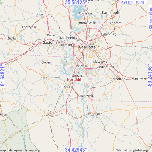
Fort Mill GPS coordinates[2]
35° 0' 26.532" North, 80° 56' 42.288" West
| Map corner | latitude | longitude |
|---|---|---|
| Upper-left | 35.58125°, | -81.64821° |
| Center: | 35.00737°, | -80.94508° |
| Lower-right: | 34.42943°, | -80.24196° |
| Map W x H: | 128.1×128.1 km | = 79.6×79.6mi |
| max Lat: | 71.29058° ⇑75.4% North |
| Fort Mill: | 35.00737° |
| min Lat: | ⇓24.6% South 19.06759° |
| min Long | Fort Mill | max Long |
| -171.73463° | -80.94508° | -66.98998° |
| W 69.6%⇐ | ⇒30.4% E |
Elevation
Elevation of Fort Mill is 193 m = 633 ft, and this is 101.8 m = 334 ft below average elevation for this country.
| Max E: |
3189 m = 10463 ft | 51.4% |
| Avg. | 294.8 m = 967 ft | |
| Fort Mill | 193 m = 633 ft | |
Min E: |
-60 m = -197 ft | 48.6% |
See also: United States elevation on elevation.city.
Geographical zone
Fort Mill is located in North temperate zone (between Tropic of Cancer and the Arctic Circle). Distance of this Northern Tropic circle is 1286.5 km =799.4 mi to South.| Distance of | km | miles | from Fort Mill |
|---|---|---|---|
| North Pole | 6114.6 | 3799.4 | to North |
| Arctic Circle | 3508.7 | 2180.2 | to North |
| Tropic Cancer | 1286.5 | 799.4 | to South |
| Equator | 3892.5 | 2418.7 | to South |


Nearby cities:
15 places around Fort Mill: (largest is in red/bold)
• Catawba
17.4 km =10.8 mi,  169°
169°
• India Hook
7 km =4.3 mi,  270°
270°
• Jaars
24.2 km =15 mi,  131°
131°
• Lake Wylie
14.3 km =8.9 mi,  321°
321°
• Lesslie
13 km =8.1 mi,  184°
184°
• Marvin
12 km =7.5 mi,  98°
98°
• Matthews
23.5 km =14.6 mi,  58°
58°
• Newport
14.3 km =8.9 mi,  262°
262°
• Pineville
9.7 km =6 mi,  29°
29°
• Riverview
3.2 km =2 mi, 260°
• Rock Hill
11.7 km =7.3 mi,  218°
218°
• Tega Cay
7.8 km =4.8 mi,  284°
284°
• Waxhaw
20.6 km =12.8 mi,  116°
116°
• Weddington
16.9 km =10.5 mi,  84°
84°
• Wesley Chapel
24.6 km =15.3 mi,  90°
90°
Sources, notices
• [Note1] Compared only with cities in United States existing in our database
• [Src1] Map data: © OpenStreetMap contributors (CC-BY-SA)
• [Src2] Other city data from geonames.org with taken over terms of usage.
• [Src3] Geographical zone / Annual Mean Temperature by Robert A. Rohde @ Wikipedia
