Manteo geodata
Manteo (North Carolina) is a seat of a second-order administrative division; located in United States in America/New_York (GMT-4) time zone. With population of 1,388 people, there are 14167 cities with bigger population in this country. Compared to other cities in United States, 70.9% of cities are located further ↑North; 85.1% of cities are located further ←West and 96.6% of cities have higher elevation than Manteo. Note1
Administrative division(s):
- Level 1: North Carolina
- Level 2: Dare County
- Level 3: Township of Nags Head


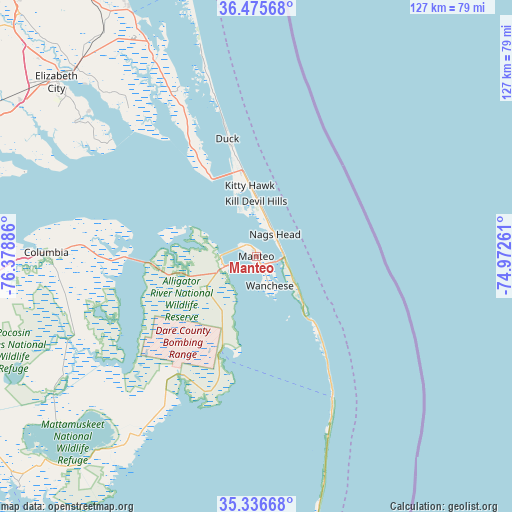
Manteo GPS coordinates[2]
35° 54' 29.628" North, 75° 40' 32.628" West
| Map corner | latitude | longitude |
|---|---|---|
| Upper-left | 36.47568°, | -76.37886° |
| Center: | 35.90823°, | -75.67573° |
| Lower-right: | 35.33668°, | -74.97261° |
| Map W x H: | 126.6×126.6 km | = 78.7×78.7mi |
| max Lat: | 71.29058° ⇑70.9% North |
| Manteo: | 35.90823° |
| min Lat: | ⇓29.1% South 19.06759° |
| min Long | Manteo | max Long |
| -171.73463° | -75.67573° | -66.98998° |
| W 85.1%⇐ | ⇒14.9% E |
Elevation
Elevation of Manteo is 7 m = 23 ft, and this is 287.8 m = 944 ft below average elevation for this country.
| Max E: |
3189 m = 10463 ft | 96.6% |
| Avg. | 294.8 m = 967 ft | |
| Manteo | 7 m = 23 ft | |
Min E: |
-60 m = -197 ft | 3.4% |
See also: United States elevation on elevation.city.
Geographical zone
Manteo is located in North temperate zone (between Tropic of Cancer and the Arctic Circle). Distance of this Northern Tropic circle is 1386.7 km =861.7 mi to South.| Distance of | km | miles | from Manteo |
|---|---|---|---|
| North Pole | 6014.4 | 3737.2 | to North |
| Arctic Circle | 3408.6 | 2118 | to North |
| Tropic Cancer | 1386.7 | 861.7 | to South |
| Equator | 3992.6 | 2480.9 | to South |


Nearby cities:
15 places around Manteo: (largest is in red/bold)
• Avon
63.6 km =39.5 mi,  166°
166°
• Buxton
72.2 km =44.9 mi, 170°
• Camden
64.6 km =40.1 mi,  316°
316°
• Columbia
51.9 km =32.2 mi,  271°
271°
• Currituck
67.5 km =41.9 mi,  333°
333°
• Elizabeth City
67.2 km =41.8 mi,  309°
309°
• Hatteras
76.6 km =47.6 mi,  180°
180°
• Hertford
77.7 km =48.3 mi,  293°
293°
• Kill Devil Hills
13.6 km =8.5 mi,  359°
359°
• Kitty Hawk
17.6 km =10.9 mi,  351°
351°
• Manns Harbor
8.2 km =5.1 mi,  252°
252°
• Nags Head
7.2 km =4.5 mi,  40°
40°
• Southern Shores
26.2 km =16.3 mi, 348°
• Wanchese
8 km =5 mi,  155°
155°
• Winfall
78.8 km =49 mi,  296°
296°
Sources, notices
• [Note1] Compared only with cities in United States existing in our database
• [Src1] Map data: © OpenStreetMap contributors (CC-BY-SA)
• [Src2] Other city data from geonames.org with taken over terms of usage.
• [Src3] Geographical zone / Annual Mean Temperature by Robert A. Rohde @ Wikipedia
