Elizabeth City geodata
Elizabeth City (North Carolina) is a seat of a second-order administrative division; located in United States in America/New_York (GMT-4) time zone. With population of 17,988 people, there are 2785 cities with bigger population in this country. Compared to other cities in United States, 69% of cities are located further ↑North; 83.3% of cities are located further ←West and 98.1% of cities have higher elevation than Elizabeth City. Note1
Administrative division(s):
- Level 1: North Carolina
- Level 2: Pasquotank County
- Level 3: Township of Mount Hermon


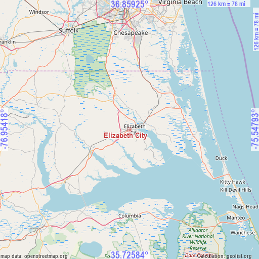
Elizabeth City GPS coordinates[2]
36° 17' 40.56" North, 76° 15' 3.78" West
| Map corner | latitude | longitude |
|---|---|---|
| Upper-left | 36.85925°, | -76.95418° |
| Center: | 36.2946°, | -76.25105° |
| Lower-right: | 35.72584°, | -75.54793° |
| Map W x H: | 126×126 km | = 78.3×78.3mi |
| max Lat: | 71.29058° ⇑69% North |
| Elizabeth City: | 36.2946° |
| min Lat: | ⇓31% South 19.06759° |
| min Long | Elizabeth City | max Long |
| -171.73463° | -76.25105° | -66.98998° |
| W 83.3%⇐ | ⇒16.7% E |
Elevation
Elevation of Elizabeth City is 5 m = 16 ft, and this is 289.8 m = 951 ft below average elevation for this country.
| Max E: |
3189 m = 10463 ft | 98.1% |
| Avg. | 294.8 m = 967 ft | |
| Elizabeth City | 5 m = 16 ft | |
Min E: |
-60 m = -197 ft | 1.9% |
See also: United States elevation on elevation.city.
Geographical zone
Elizabeth City is located in North temperate zone (between Tropic of Cancer and the Arctic Circle). Distance of this Northern Tropic circle is 1429.7 km =888.4 mi to South.| Distance of | km | miles | from Elizabeth City |
|---|---|---|---|
| North Pole | 5971.5 | 3710.5 | to North |
| Arctic Circle | 3365.6 | 2091.3 | to North |
| Tropic Cancer | 1429.7 | 888.4 | to South |
| Equator | 4035.6 | 2507.6 | to South |


Nearby cities:
15 places around Elizabeth City: (largest is in red/bold)
• Camden
8 km =5 mi,  62°
62°
• Chesapeake
58.4 km =36.3 mi,  357°
357°
• Columbia
41.9 km =26 mi,  180°
180°
• Currituck
27.3 km =17 mi,  50°
50°
• Edenton
41.4 km =25.7 mi,  230°
230°
• Gatesville
46.6 km =29 mi,  285°
285°
• Hertford
22.5 km =14 mi,  238°
238°
• Kill Devil Hills
59.4 km =36.9 mi,  119°
119°
• Kitty Hawk
55.2 km =34.3 mi, 117°
• Moyock
26.4 km =16.4 mi,  14°
14°
• Roper
56.7 km =35.2 mi,  215°
215°
• South Suffolk
55.9 km =34.7 mi,  327°
327°
• Southern Shores
49.7 km =30.9 mi,  110°
110°
• Suffolk
56.7 km =35.2 mi, 328°
• Winfall
20.8 km =12.9 mi,  246°
246°
Sources, notices
• [Note1] Compared only with cities in United States existing in our database
• [Src1] Map data: © OpenStreetMap contributors (CC-BY-SA)
• [Src2] Other city data from geonames.org with taken over terms of usage.
• [Src3] Geographical zone / Annual Mean Temperature by Robert A. Rohde @ Wikipedia
