Marshville geodata
Marshville (North Carolina) is a populated place; located in United States in America/New_York (GMT-4) time zone. With population of 2,638 people, there are 10313 cities with bigger population in this country. Compared to other cities in United States, 75.5% of cities are located further ↑North; 71.3% of cities are located further ←West and 57.3% of cities have higher elevation than Marshville. Note1
Administrative division(s):
- Level 1: North Carolina
- Level 2: Union County
- Level 3: Township of Marshville


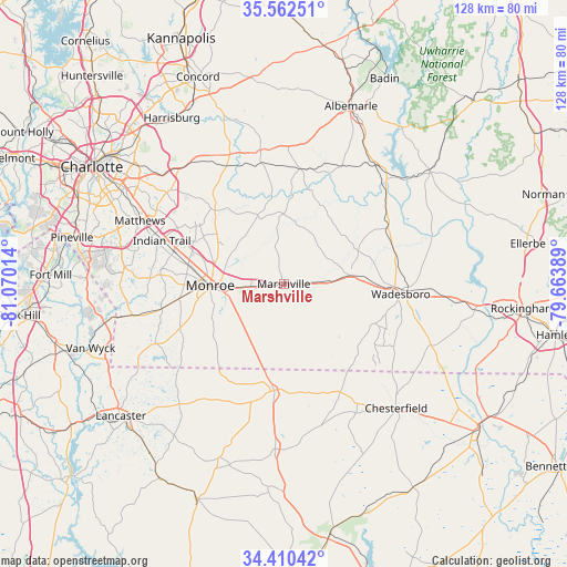
Marshville GPS coordinates[2]
34° 59' 18.564" North, 80° 22' 1.236" West
| Map corner | latitude | longitude |
|---|---|---|
| Upper-left | 35.56251°, | -81.07014° |
| Center: | 34.98849°, | -80.36701° |
| Lower-right: | 34.41042°, | -79.66389° |
| Map W x H: | 128.1×128.1 km | = 79.6×79.6mi |
| max Lat: | 71.29058° ⇑75.5% North |
| Marshville: | 34.98849° |
| min Lat: | ⇓24.5% South 19.06759° |
| min Long | Marshville | max Long |
| -171.73463° | -80.36701° | -66.98998° |
| W 71.3%⇐ | ⇒28.7% E |
Elevation
Elevation of Marshville is 169 m = 554 ft, and this is 125.8 m = 413 ft below average elevation for this country.
| Max E: |
3189 m = 10463 ft | 57.3% |
| Avg. | 294.8 m = 967 ft | |
| Marshville | 169 m = 554 ft | |
Min E: |
-60 m = -197 ft | 42.7% |
See also: United States elevation on elevation.city.
Geographical zone
Marshville is located in North temperate zone (between Tropic of Cancer and the Arctic Circle). Distance of this Northern Tropic circle is 1284.4 km =798.1 mi to South.| Distance of | km | miles | from Marshville |
|---|---|---|---|
| North Pole | 6116.7 | 3800.7 | to North |
| Arctic Circle | 3510.8 | 2181.5 | to North |
| Tropic Cancer | 1284.4 | 798.1 | to South |
| Equator | 3890.4 | 2417.4 | to South |


Nearby cities:
15 places around Marshville: (largest is in red/bold)
• Ansonville
26.8 km =16.7 mi,  61°
61°
• Burnsville
17.7 km =11 mi,  38°
38°
• Fairview
22.8 km =14.2 mi,  317°
317°
• Hemby Bridge
27 km =16.8 mi,  298°
298°
• Lake Park
26.7 km =16.6 mi,  294°
294°
• Mineral Springs
28.1 km =17.5 mi,  258°
258°
• Monroe
16.6 km =10.3 mi,  268°
268°
• Oakboro
26.6 km =16.5 mi,  7°
7°
• Pageland
24 km =14.9 mi,  185°
185°
• Polkton
15.3 km =9.5 mi,  81°
81°
• Stanfield
27.8 km =17.3 mi,  348°
348°
• Unionville
17 km =10.6 mi,  310°
310°
• Wadesboro
26.5 km =16.5 mi,  94°
94°
• Wesley Chapel
28.1 km =17.5 mi, 274°
• Wingate
7.5 km =4.7 mi, 266°
Sources, notices
• [Note1] Compared only with cities in United States existing in our database
• [Src1] Map data: © OpenStreetMap contributors (CC-BY-SA)
• [Src2] Other city data from geonames.org with taken over terms of usage.
• [Src3] Geographical zone / Annual Mean Temperature by Robert A. Rohde @ Wikipedia
