Newland geodata
Newland (North Carolina) is a seat of a second-order administrative division; located in United States in America/New_York (GMT-4) time zone. With population of 686 people, there are 18824 cities with bigger population in this country. Compared to other cities in United States, 70% of cities are located further ↑North; 65.8% of cities are located further ←West and 94% of cities have lower elevation than Newland. Note1


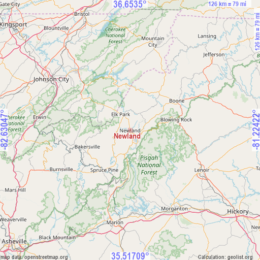
Newland GPS coordinates[2]
36° 5' 14.46" North, 81° 55' 38.424" West
| Map corner | latitude | longitude |
|---|---|---|
| Upper-left | 36.6535°, | -82.63047° |
| Center: | 36.08735°, | -81.92734° |
| Lower-right: | 35.51709°, | -81.22422° |
| Map W x H: | 126.4×126.4 km | = 78.5×78.5mi |
| max Lat: | 71.29058° ⇑70% North |
| Newland: | 36.08735° |
| min Lat: | ⇓30% South 19.06759° |
| min Long | Newland | max Long |
| -171.73463° | -81.92734° | -66.98998° |
| W 65.8%⇐ | ⇒34.2% E |
Elevation
Elevation of Newland is 1101 m = 3612 ft, and this is 806.2 m = 2645 ft above average elevation for this country.
| Max E: |
3189 m = 10463 ft | 6% |
| Newland | 1101 m 3612 ft | |
| Avg. | 294.8 m = 967 ft | |
Min E: |
-60 m = -197 ft | 94% |
See also: United States elevation on elevation.city.
Geographical zone
Newland is located in North temperate zone (between Tropic of Cancer and the Arctic Circle). Distance of this Northern Tropic circle is 1406.6 km =874 mi to South.| Distance of | km | miles | from Newland |
|---|---|---|---|
| North Pole | 5994.5 | 3724.8 | to North |
| Arctic Circle | 3388.6 | 2105.6 | to North |
| Tropic Cancer | 1406.6 | 874 | to South |
| Equator | 4012.5 | 2493.3 | to South |


Nearby cities:
15 places around Newland: (largest is in red/bold)
• Bakersville
22.3 km =13.9 mi,  249°
249°
• Banner Elk
9.8 km =6.1 mi,  30°
30°
• Blowing Rock
23.1 km =14.4 mi,  76°
76°
• Boone
26.9 km =16.7 mi,  57°
57°
• Burnsville
38.6 km =24 mi,  240°
240°
• Central
42 km =26.1 mi,  309°
309°
• Elizabethton
38.6 km =24 mi,  318°
318°
• Foscoe
16.7 km =10.4 mi, 60°
• Gamewell
38.4 km =23.9 mi,  129°
129°
• Glen Alpine
42 km =26.1 mi,  161°
161°
• Hunter
37.8 km =23.5 mi,  326°
326°
• Lenoir
39.9 km =24.8 mi,  118°
118°
• Roan Mountain
17.7 km =11 mi, 313°
• Spruce Pine
22.8 km =14.2 mi,  212°
212°
• Unicoi
39.8 km =24.7 mi,  287°
287°
Sources, notices
• [Note1] Compared only with cities in United States existing in our database
• [Src1] Map data: © OpenStreetMap contributors (CC-BY-SA)
• [Src2] Other city data from geonames.org with taken over terms of usage.
• [Src3] Geographical zone / Annual Mean Temperature by Robert A. Rohde @ Wikipedia
