Spruce Pine geodata
Spruce Pine (North Carolina) is a populated place; located in United States in America/New_York (GMT-4) time zone. With population of 2,134 people, there are 11518 cities with bigger population in this country. Compared to other cities in United States, 70.8% of cities are located further ↑North; 65.3% of cities are located further ←West and 91.8% of cities have lower elevation than Spruce Pine. Note1
Administrative division(s):
- Level 1: North Carolina
- Level 2: Mitchell County
- Level 3: Township of Grassy Creek


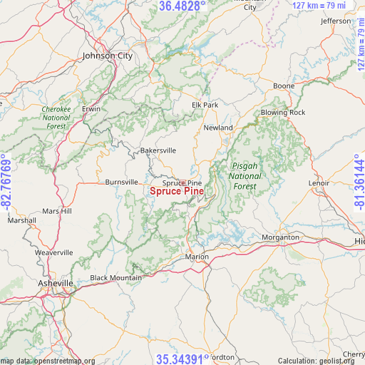
Spruce Pine GPS coordinates[2]
35° 54' 55.44" North, 82° 3' 52.416" West
| Map corner | latitude | longitude |
|---|---|---|
| Upper-left | 36.4828°, | -82.76769° |
| Center: | 35.9154°, | -82.06456° |
| Lower-right: | 35.34391°, | -81.36144° |
| Map W x H: | 126.6×126.6 km | = 78.7×78.7mi |
| max Lat: | 71.29058° ⇑70.8% North |
| Spruce Pine: | 35.9154° |
| min Lat: | ⇓29.2% South 19.06759° |
| min Long | Spruce Pine | max Long |
| -171.73463° | -82.06456° | -66.98998° |
| W 65.3%⇐ | ⇒34.7% E |
Elevation
Elevation of Spruce Pine is 779 m = 2556 ft, and this is 484.2 m = 1589 ft above average elevation for this country.
| Max E: |
3189 m = 10463 ft | 8.2% |
| Spruce Pine | 779 m 2556 ft | |
| Avg. | 294.8 m = 967 ft | |
Min E: |
-60 m = -197 ft | 91.8% |
See also: United States elevation on elevation.city.
Geographical zone
Spruce Pine is located in North temperate zone (between Tropic of Cancer and the Arctic Circle). Distance of this Northern Tropic circle is 1387.5 km =862.2 mi to South.| Distance of | km | miles | from Spruce Pine |
|---|---|---|---|
| North Pole | 6013.6 | 3736.7 | to North |
| Arctic Circle | 3407.8 | 2117.5 | to North |
| Tropic Cancer | 1387.5 | 862.2 | to South |
| Equator | 3993.4 | 2481.4 | to South |


Nearby cities:
15 places around Spruce Pine: (largest is in red/bold)
• Bakersville
14 km =8.7 mi,  322°
322°
• Banner Elk
32.6 km =20.3 mi,  32°
32°
• Banner Hill
40.3 km =25 mi,  306°
306°
• Black Mountain
40.4 km =25.1 mi,  214°
214°
• Burnsville
21.3 km =13.2 mi,  270°
270°
• Foscoe
38.4 km =23.9 mi,  44°
44°
• Glen Alpine
33 km =20.5 mi,  128°
128°
• Marion
26.2 km =16.3 mi,  169°
169°
• Montreat
37 km =23 mi,  215°
215°
• Morganton
39.1 km =24.3 mi,  118°
118°
• Newland
22.8 km =14.2 mi, 32°
• Old Fort
33.5 km =20.8 mi,  198°
198°
• Roan Mountain
31.2 km =19.4 mi,  359°
359°
• Unicoi
40.3 km =25 mi, 320°
• West Marion
28.8 km =17.9 mi, 172°
Sources, notices
• [Note1] Compared only with cities in United States existing in our database
• [Src1] Map data: © OpenStreetMap contributors (CC-BY-SA)
• [Src2] Other city data from geonames.org with taken over terms of usage.
• [Src3] Geographical zone / Annual Mean Temperature by Robert A. Rohde @ Wikipedia
