Sneads Ferry geodata
Sneads Ferry (North Carolina) is a populated place; located in United States in America/New_York (GMT-4) time zone. With population of 2,646 people, there are 10294 cities with bigger population in this country. Compared to other cities in United States, 77.4% of cities are located further ↑North; 79.3% of cities are located further ←West and 95.7% of cities have higher elevation than Sneads Ferry. Note1
Administrative division(s):
- Level 1: North Carolina
- Level 2: Onslow County
- Level 3: Township of Stump Sound


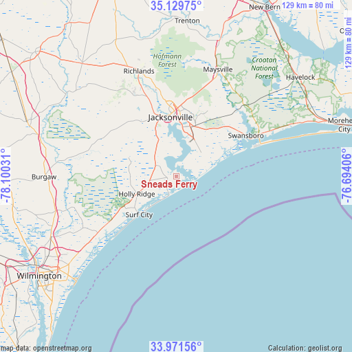
Sneads Ferry GPS coordinates[2]
34° 33' 9.612" North, 77° 23' 49.848" West
| Map corner | latitude | longitude |
|---|---|---|
| Upper-left | 35.12975°, | -78.10031° |
| Center: | 34.55267°, | -77.39718° |
| Lower-right: | 33.97156°, | -76.69406° |
| Map W x H: | 128.8×128.8 km | = 80×80mi |
| max Lat: | 71.29058° ⇑77.4% North |
| Sneads Ferry: | 34.55267° |
| min Lat: | ⇓22.6% South 19.06759° |
| min Long | Sneads Ferry | max Long |
| -171.73463° | -77.39718° | -66.98998° |
| W 79.3%⇐ | ⇒20.7% E |
Elevation
Elevation of Sneads Ferry is 8 m = 26 ft, and this is 286.8 m = 941 ft below average elevation for this country.
| Max E: |
3189 m = 10463 ft | 95.7% |
| Avg. | 294.8 m = 967 ft | |
| Sneads Ferry | 8 m = 26 ft | |
Min E: |
-60 m = -197 ft | 4.3% |
See also: United States elevation on elevation.city.
Geographical zone
Sneads Ferry is located in North temperate zone (between Tropic of Cancer and the Arctic Circle). Distance of this Northern Tropic circle is 1236 km =768 mi to South.| Distance of | km | miles | from Sneads Ferry |
|---|---|---|---|
| North Pole | 6165.2 | 3830.9 | to North |
| Arctic Circle | 3559.3 | 2211.6 | to North |
| Tropic Cancer | 1236 | 768 | to South |
| Equator | 3841.9 | 2387.2 | to South |


Nearby cities:
15 places around Sneads Ferry: (largest is in red/bold)
• Bogue
36.8 km =22.9 mi,  63°
63°
• Cape Carteret
34.3 km =21.3 mi, 63°
• Cedar Point
33.3 km =20.7 mi, 63°
• Half Moon
30.9 km =19.2 mi,  349°
349°
• Hampstead
35.3 km =21.9 mi,  234°
234°
• Holly Ridge
15.8 km =9.8 mi,  246°
246°
• Jacksonville
22.6 km =14 mi, 352°
• Maysville
42 km =26.1 mi,  21°
21°
• North Topsail Beach
7.6 km =4.7 mi,  204°
204°
• Peletier
34.8 km =21.6 mi, 55°
• Piney Green
19.5 km =12.1 mi, 21°
• Pumpkin Center
26.7 km =16.6 mi,  4°
4°
• Richlands
40.9 km =25.4 mi,  340°
340°
• Surf City
19.5 km =12.1 mi,  224°
224°
• Swansboro
29.5 km =18.3 mi, 59°
Sources, notices
• [Note1] Compared only with cities in United States existing in our database
• [Src1] Map data: © OpenStreetMap contributors (CC-BY-SA)
• [Src2] Other city data from geonames.org with taken over terms of usage.
• [Src3] Geographical zone / Annual Mean Temperature by Robert A. Rohde @ Wikipedia
